The Weminuche wilderness is located in Colorado, some 5-6 hours’ drive from Denver. I had an opportunity to spend a week there this August. Specifically, a hike along the Continental Divide Trail several miles Southwest of Creede.
We started at the Thirty Mile campground near the Rio Grande reservoir about 20-30 min drive along a gravel road from Hwy CO 149 at about 9.5 k ft altitude. Conveniently, there’s a parking lot for hikers and fishermen. The campground itself was pretty busy, unsurprisingly so in high season. I had spent the night before at Silver Creek divide, further along the highway towards Lake City and even higher up. Shall we say the sleep, however much I got, was not great, but the view of the night sky was fantastic.
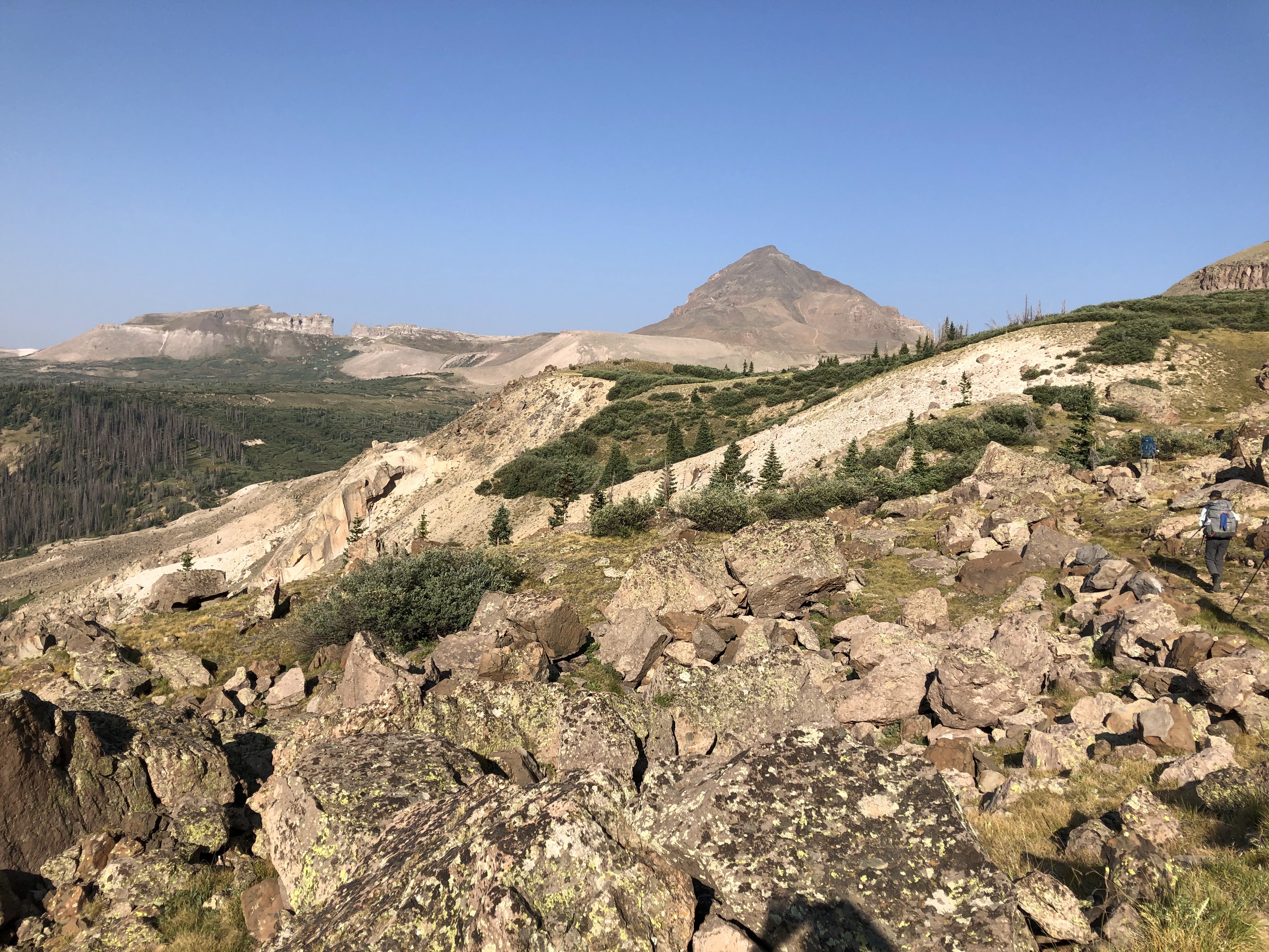
We hiked along the Squaw Valley trail for a few miles South and then climbed steeply for about 2 k ft up the left side of the valley on primitive, but discernible trail to reach an open ridge. The typical Colorado later afternoon thunderstorm was threatening with thunder and lightning in the not too far distance. We left the ridge expeditiously and descended steeply through a burn area. There were remnants of a well built trail, but the deadfall across it made its use difficult. Instead we descended cross country to reach the Little Squaw Creek valley where we camped well away from the "widow makers", dead trees not yet down, that abounded.
Next morning we climbed out of the valley on the other side of the valley, following a primitive but easily followable trail to reach a swampy area on a plateau at about 11.2 k ft.

From there we went off trail, climbing much more gently than before through willows and on grassy ramps to a ridge from which we descended to the Red Lakes for lunch and a dry out of tents and sleeping bags. There we intersected with a primitive trail which led us to Trout Lake via a final rough, steep and brushy descent.

The late afternoon brought some threatening weather all around us, but in the immediate vicinity of the lake it remained almost completely dry.


And then, just like that, the weather turned for the better
It turned out to be another mostly sleepless night, or nearly so, with another brilliant night sky with a view of the Milky Way and many shooting stars. When Nature called in the middle of the night I almost managed to lose my way on the return to my tent. Luckily I had studied the terrain in the afternoon and recognized a meadow close to the water and from there found my way back to the tent.
We climbed out of the shallow side of the bowl that Trout Lake is located in and wound our way along the Continental Divide Trail. The trail ran along steep sides of hills and I recognized the area from descriptions of CDT hikers doing this section in July with snow. That would not be easy! Along the way we encountered a large Forest Service trail crew along with a National Conservation Corps trail crew who were pushing back the brush, cutting trees blocking the trail, cleaning and installing drainages. Thank you trail crews!
Towards the afternoon after an already significant climb we climbed up to almost the top of a 12800 ft peak, contouring just below the top, to reach a junction with a more primitive trail that led down steeply to Squaw Lake, an about 900 ft loss in altitude, which we already knew we would have to ascend back up next morning. Walking high and sleeping low (or as low as possible) as the old saying goes.
We hikers really are a strange lot! We cut off the back half of the handle of the tooth brush to save some weight, may spend hundreds of dollars to save a few oz on gear weight. Yet no hesitation to go down and up 900 ft to camp at a lake shore. Just sign me up! Nuts! In an entirely good way.
It was another great night of cowboy camping, watching the Milky Way and the myriad of stars. In the morning we climbed out of the hole, hiked cross country to link up with the CDT again and followed it to Rincon La Vacca (cow corner/bay) valley. We briefly considered to climb Rio Grande pyramid that day, but as the photo below shows, the weather was not that stable (the worst of it was to the back of me when I took the picture). Cooler heads prevailed and instead we followed the valley to Weminuche Pass where we spent the night. Yet another cloudless, clear cold night with a great view of the Milky Way. Some shut-eye too.

View of Rio Grande pyramid from Rincon La Vacca valley
Next morning we followed the Skyline Opal Lake trail climbing some 1600 ft and contouring along a steep hillside to the base of the Rio Grande Pyramid, a 13800 ft peak we intended to climb. The pyramid is located right next to "the window", an indentation in a rock wall that looks as if a tooth was missing in a denture. I remember seeing this in the distance as I was hiking the Colorado trail after going over the first pass coming up from Molas lake. At that time I thought immediately of Mordor from LOTR.

You leave the Skyline Opal lake trail and head up to a saddle between the Rio Grande pyramid and another, lower and gentler pyramid to its right. As you approach the pyramid, even from the skyline trail, you see a whitish line on a pink/orange background going up straight towards the peak. I wanted to make a joke that this was going to be the trail to the top. It was not a joke, that was exactly what it was: a steep ascent over scree. The first section was slightly less steep and had a solid dirt base, the second section was steeper and looser with some mini switchbacks of about 10 ft amplitude in it. In this section it turned out to be easier to climb over talus on either side of the scree-filled chute rather than the one step up, half step back approach of walking on the scree. At the top of the scree section we encountered a flat talus field suitable for a rest stop before a long, steep climb across talus to the top.
It turns out that there are several roads leading to Rome. There were some cairns along the way and some short stretches of dirt that were clearly used as part of the “path”. This was a fun climb, but the air unsurprisingly was thin. Yours truly was huffing and puffing like the little train that could.
The climb down the talus was not too difficult, but it is a bit more risky as it is harder to test whether a rock below is stable. I promptly took a fall when a sound-looking rock gave way. I nipped my right forearm, only realizing further down when a red spot appeared on my pants that I actually had punctured my skin. It was minor and the bleeding stopped without any intervention. The scree slope was steep and loose enough that one could ski down it, so that went by pretty quickly.


View North from Rio Grande pyramid
Since our permit required us to camp on the North side of the divide we hoofed over there first along the Skyline trail, then along the CDT through a willow garden and across grassy plains and descended into the Ute Creek valley where we found a not so great but acceptable camp site.
Next morning we descended the valley further and set up camp on a small hill close to Black Lake. After another great night we set out for a day hike to take in more of the CDT and the Ute lakes. Alas, we got caught in a thunderstorm, luckily mostly thunder and lightning and not a downpour. We got wet a bit, but not soaked, from freezing rain and plain old rain. We returned to camp after visiting some of the Ute Lakes. The afternoon cleared up as if the thunderstorm had never happened and the early evening was very pleasant in the setting sun. Next morning we hoofed out to the Ute Creek trailhead where the cars were waiting and headed for Creede for burgers and beer.

Last camp site in Ute Creek valley near Black lake
All in all a great six days under very favorable conditions. While we saw many traces of animals such as scat and hoof prints, we did not see many animals themselves. Maybe they had checked their calendar on Google and noticed that the bow hunting season was to begin soon and decided that it behoofed them, if you pardon the pun, to hoof to more inaccessible meadows.
I think it was Alan Dixon who told me about the extent of damage to the trees in the Weminuche and he surely did not exaggerate. In difference to the devastation from fires I witnessed along the GET, the trees in the Weminuche are still standing since the "change agent" is the bark beetle, but the sight is no less or not much less depressing. There is some obvious new growth in amongst the deadwood and the discussion centered around whether the trees were growing fast or slow. Given the altitude yours truly favored the slow growth hypothesis.
I had been in the general neighborhood, mostly along the Colorado Trail for trail crew or during my through hike. From these vantage points I had not seen the range farther to the North which really invites another visit to the area and more exploration. I'll be baaaaack!
No comments:
Post a Comment