With my original summer 2020 hiking plans for the Cordillera Huayhuash and the Cordillera Blanca in Peru in shambles owing to Covid, I needed to come up with an acceptable, challenging alternative. I therefore planned on spending the summer in California, specifically the Sierra High Route and the Southern Sierra High Route as a similarly alpinistically challenging adventure. Since neither of these routes dips below 10k feet for long, I thought it was going to be prudent to throw in an acclimatization hike or trail crew work that would get me adapted to 8k-10k feet altitude since I live at barely 50 ft above sea level. With most scheduled trail crews cancelled owing to Covid, the Tahoe Rim Trail fit the bill for this acclimatization hike. It can be done in about 10 days without too much trouble and only requires a permit for crossing the Desolation Wilderness. The TRT also comes recommended by Amy and James at doingmiles.com, and I have found that you can take their recommendations to the bank.
Owing to closures of Yosemite and the Lake Tahoe area due to Covid and the relatively late (relative to my preferred dates) opening of the area around Truckee and Lake Tahoe, things did not quite work out as I had imagined. Once these areas opened up and I was convinced that they would not close up again right away, I applied for my SHR and SoSHR permits. Little did I know that this is a month-long to six-week long process. I am sure the Forest Service (FS) front line workers do the best they can with the tools they have, but these tools appear to suck pretty badly when you consider what you can do on your smart phone these days with a couple of clicks. It surely did not help that the offices had moved to virtual operations and you could not talk to a ranger directly and had to play phone/email tag.
In the end I submitted my SHR and SoSHR permit applications in the hope that the permit would come through by the time I finished the TRT and I took off for Reno.
I had planned on doing the trail in 11-12 calendar days, starting late in the afternoon of the first day after arriving from Reno and hoping to finish around noon on the last day in order to be able to make it back to Reno where I would be doing my last minute prep for the SHR/SoSHR. I chose to start in Tahoe City which would allow for a resupply not quite half-way through in Kingsbury, NV. This plan accommodated the fact that the East rim of the Lake is pretty dry and requires longer water carries. By that time my food supplies would be down and the total weight of my pack would be reasonable throughout.
Needless to say that also did not quite work out as planned. For one I was a little bit faster than I thought I would be. This faster pace put me at Kingsbury on Friday July 3rd, the day the Fourth of July holiday would be celebrated and the PO would be closed. Then it turns out that the POs in that part of Nevada are not open on Saturday, a fact that had not occurred to me to check out beforehand. All of a sudden I was going to be spinning my heels at Kingsbury for two or three days. Another unexpected piece of intelligence was that the Kingsbury PO on state Route 207 does not do General Delivery and they forward the package up the road to the Zephyr Cove PO. Luckily that had not happened yet with my parcel and I could retrieve mine at the intended PO. Just a word of caution to others. The Zephyr PO is 3.5 miles up the road (US 50) from the one on SR 207. So if your parcel lands there the retrieval of it almost becomes a day long operation.
Tahoe City to Brockville Summit
To say this right off the bat, this section is the most hohum portion of the entire TRT. After climbing and contouring for some four or five hours I camped in a small clearing off trail, cooked my dinner and tried to get over my jet lag. I cowboy camped and as usual sleep overtook me only in the wee hours of the morning.
The next day I made my way through more forest without much in terms of scenery, botany or anything else to hold my attention. Hopefully the scenery would improve or this was going to be one drag! Luckily, the trail comes recommended and hopes were high that the scenery would improve.
That evening I crossed the Brockville Summit Road and made another cowboy camp deep in an old growth forest. Right before crossing the road I got lucky in meeting two young guys approaching the end of their hike who had stashed water near the road crossing and they were happy to share what they did not need. I recommend a water cache at that location if you are in the business of caching before doing this hike. There is not much of a natural source, at least after as dry a Spring and early Summer as this year (2020) and the only alternative is yogying some water from day hikers at the road crossing.
And of course, the sleep sucked yet again. I really don’t understand how I can crank out these miles without decent sleep, but trip after trip this is what I do.
Brockville Summit to Mt. Rose area.
Next morning I climbed out of the forest towards Rifle Peak and as I exited the forest the views markedly improved. I briefly chatted with a group of local trail runners and after that had the trail almost all to myself all day. The views over the North shore and towards the South of the lake basin were really great.


In mid-afternoon I ran low on water and tried to collect melt water from residual snow fields on Mt. Rose Knob. That was surprisingly unsuccessful, the melt rate really was not at all what I would have expected for the time of year. A descent to Mud Lake was more successful. Contrary to what its name might imply, Mud Lake had very clear, cool water and my water problem was easily solved. As I climbed higher up towards Mt. Baldy I started to think about how to pace my hike to be able to reach Kingsbury when the post office would be open. As I checked out the Kingsbury Rise PO hours, I found out to my horror that they were not open on Saturday, Friday was going to be the day the 4th of July was going to be observed, and Sunday they were closed anyway. So they were going to be closed for three straight days. There was no way I could possibly spend three days walking from Mt. Rose to Kingsbury, maybe on my knees or walking on my hands or walking backwards, but not at something resembling my regular pace. And the food I was carrying would also not be lasting for that long. Since I had not yet recovered from my weight loss from my GET hike I also could not use an extended East rim hike without food as a weight loss opportunity. So a change of plans was in order.
I got off the TRT just past Mt. Baldy and walked the road to Third Creek Pond. Shortly before the road reaches the lake there is a piped spring on the left side of the road. Very convenient! I camped close to the spring in an old growth forest that provided some shielding from a cold, persistent wind.
Next morning I headed down to SR 431, walked down to the Ophi Creek/Tahoe Meadows trailhead and descended from there to Incline Village along a bike trail in the forest that ended in a subdivision. From there down Country Club Road down to the bus stop of the local bus system where a bus brought me back to Tahoe City. Yeah, public transportation! I must say, it is convenient to be on a trail where you also have internet access so that you can make plan changes based on data rather than your hopes. It was a first for me, but I won’t make it a habit!
I recovered my car, drove to Kingsbury to retrieve my food parcel. On my drive back I also cached some water along the route where I could conveniently do so. I parked the car at the Ophir Creek trailhead in late afternoon.
Ophir Creek Meadows to Spooner Lake
The early portion of this section, about 8 miles to Tunnel Creek Rd, is said to be the most popular section of the TRT. In particular it is popular with mountain bikers, so popular in fact that it is suggested strongly that mountain bikers only use this section on even-numbered days and refrain from biking on odd-numbered days.
Now my personal opinions about mountain bikers, few exceptions notwithstanding, is that they are one of four kinds of pests the hiker encounters in the backcountry: chiggers, skeeters, deer flies and bikers, in order of increasing size, not necessarily in order of annoyance.
This being July 2nd I encountered a few bikers, but the terrain was not suitable anyway for downhill races at the speed of light on trails with limited visibility. So while there were bikers, they were not causing the usual annoyance that evening.
After a couple of miles I found a ridge on the lake-side of the trail which made for a private and wind-protected cowboy camp and spent an uneventful night.
As I took off in early morning hours I mentally prepared for a busy day, this being the Friday on which July 4th was being observed. However, this concern proved to be unnecessary, at least early in the morning. There was one pair of bikers for whom the rules apparently did not apply. Otherwise I ran into a few trail runners and into a few day hikers, but definitely not hordes of bikers or hikers.
The trail afforded the occasional grand view of Lake Tahoe from high above and the opposing shore where I would be hiking and later be ending my hike a few days hence. There were stretches of hiking in old-growth forests with massive spruce trees with a base-width twice my shoulder width.

While I had no intention to camp at one of the few permitted camp sites on the East shore, near Marlette Peak, reaching it was part of the plan as it also features a spring where water could be obtained. The Guthook app indicated the spring, but online reports from TRT hikers suggested that it is “not working”, whatever that may mean. I reached the junction of the trail before Marlette Peak where the trail divides and you get the choice of walking around the peak on either the lake-facing side or the backside. These two alternative trails join again on the other side of the peak. Because of the need for water I chose the backside trail. It descends a little in the forest and then contours across an open hillside to then again enter a forest. Shortly after entering the forest I noticed a little rill, which upon inspection provided a modest flow of clear, cold water. Just the ticket!
As I was collecting water by means of a ziploc bag a mountain biker came hurling through at the speed of light hurling abuse at me as he screamed by. Two of his mates, a father/son pair, came a little later and I was ready for them, but they were polite anyway and reduced their speed appropriately.
With my water bags filled I returned to the spot where the trails separated and took the lake-side alternative around the peak for the better view. This is the obvious way to go, the views are superior and the side-trip to the rill sets you back about 20 min, there and back.

Marlette Lake in foreground and Lake Tahoe in back
As you reach the trail junction of the alternative trails around Marlette Pk. you cross a 4WD road that leads down to Marlette Lake and a while later you cross another dirt road, this one prominent enough to have a name: Hobart Rd.. Here, the entity responsible for the signage actually does spell it out that the source at the Marlette campground is not active at this time. They direct the hiker down the road in direction of Lake Tahoe, some 0.75 miles, to a spot where the road crosses a stream. So whichever way you follow, there is an opportunity to replenish water supplies around Marlette Pk. and in either case it’s not too far off track.
Hobart Rd also defines the beginning of a section, lasting all the way to Spooner Lake, where the annoying mountain bikers are not allowed to roam. The trail continues a little while out in the open as you contour below Snow Valley Peak and then enters the forest. I encountered a few hikers heading into the backcountry, but it was a pleasant walk through old-growth forest, alas without much of a view out to Lake Tahoe.
At the end of a long day I reached Spooner Lake and a convenient spot to collect water from its shore. There I met a young couple who were doing the TRT in the counterclockwise direction and had ambitious plans on daily mileage as their job required them to be back at work on a specific day. It’s nice to be retired, is all I can say.
I camped using my tent along the path leading from Spooner Lake to the Spooner trailhead for the next section leading to Kingsbury. The bugs were just a tad too bad for a cowboy camp.
Spooner Lake to Kingsbury
This section starts with a walk and climb in an old growth forest. As you exit the forest you a reach a bench, as in a geographic feature, with an open vista of Lake Tahoe and a bench, as in a piece of outdoor furniture, from which to enjoy the view. From there you continue across a bit of talus and marginal meadow before you descend back into the forest. It is bit of a drag section as you wander through the forest without much in terms of views to keep you mentally engaged but some of the old growth trees really are magnificent.
Towards the Kingsbury trailhead you have to pay attention as there is an entire network of local trails that intersects the TRT and it is easy to get off track if you don’t pay attention. I of course had to take the opportunity to not pay attention and ended up in a subdivision some way off SR 207. Here again it came in handy that the TRT is often within reach of internet connectivity so that I could use Google maps to chart a course towards the highway. In the end it did not matter as a woman whom I had passed while approaching the Kingsbury trailhead stopped and offered to give me a ride. Thanks! So in short order I reached the small cul-de-sac where a connector trail heads to the TRT. I had used this connector to cache some water there.
In short order I found a discreet spot where I camped in dense brush by the side of the trail well hidden from bikers and people walking their dogs. There was some Fourth of July partying going on in the fancy houses above, but not too bad.
Kingsbury to Armstrong Pass
Next morning I started off with a significant climb through old-growth forest until I reached the first of two ski lift tracks I had to cross according to the maps. I lost the trail here for a little while and walked over to the second lift in the company of another young couple who were also doing the TRT. It was their first day on the trail and they were going to take it easy on this day, intending to increase their mileage in subsequent days. We found the trail again by the second ski lift and hiked together for a while, then passing one another a couple of times before they sped ahead to Star Lake.
When planning my hike I had considered camping at Star Lake as well, but the amount of humanity around this body of water quickly persuaded me that this was too obvious a camping spot to be enjoyed with some solitude. I pushed on and after a climb up Freel Pass followed by a descent over long switchbacks and a contour I found a quiet camping spot off trail shortly before Armstrong Pass.
Armstrong Pass to Round Lake
After a beautiful night cowboy camping off the trail, I continued on next morning. After crossing the pass I passed by Freel Meadows, a welcome opening in the forest with a great view of the mountain ranges farther South.
The trail was busy with mountain bikers but they were all climbing and hence slow. Most had plans to descend to a road off Armstrong Pass, so no expectation of bikers coming out of nowhere from behind. I decided to call it an early day at Round Lake, which is right on the trail but was not crowded at all. It was windy but I found a nice shielded spot on the shore and enjoyed hanging out in the sun with a view of a chain of mountains to the South of me.
Round Lake to Tamarack Lake/Desolation Wilderness
Next morning, after a brief climb I left the forest and stepped out on a huge meadow below the chain of peaks I had seen in the distance from Round Lake. Here the trail makes a sharp turn to the Northwest as it joins the PCT. After crossing a few streams the trail starts to climb to a wide bench below the peaks heading more or less straight North. There are some spots with absolutely fabulously beautiful views over the basin at the Southern end of Lake Tahoe.

I had arranged online a permit for the Desolation Wilderness for July 6-8 and was now about a day behind schedule, the day I had spent retrieving my food parcel. The FS requires you carry a paper copy of the permit and the way to get it is to either have it mailed to you some two weeks before you start your hike or by picking it up at the ranger station outside South Tahoe (The option of email with pdf attachment is not on offer. It’s the 21st century FFS!) I had done neither and since I intended to reach the wilderness this day, something needed to be done. They say on their website that you can call them before 4 PM of the day you enter the wilderness. I had connectivity for my phone at a couple of spots as I hiked towards Echo Lakes, but of course the office was closed owing to covid and one had to leave a phone message after being told that they would be providing services virtually. It is fair to say they virtually provided services as opposed to virtual services, but practically they did not. I did leave about five messages and did not receive a response all day. I figured if they were not in their office, they sure as hell were not going to be in the backcountry to check permits and pushed on.
At the Chalet at Lower Echo Lake I splurged on two oranges, one of which I managed to keep for later, and two ice cream sandwiches. I then trodded along the rocky trail above Lower Echo Lake, above the cottages, and making room for day hikers coming the other way. By this time I was running low on water as there had been none available at the boat ramp by the chalet (or I had not seen a tap). To your left below you see the rocky barrier between Lower and Upper Echo Lake and you think you might be able to access water there, but then you notice more cottages and that’s the end of that. Soon after you pass the end of Upper Echo Lake there is a sign indicating the border of the Desolation Wilderness. By that time it was already clear that desolation =/= solitude, the trail was obviously heavily used as suggested by the width and shape of the trail. As I hustled along my left ankle rolled as it has the annoying habit of doing, an overuse injury that I have been struggling with ever since the Pyrenees hike. This time I was violently hurled forwards and landed head first on a granite rock that defined the left border of the trail. This effing hurt! It was also clear that I was bleeding from some sort of head wound and that my sun glasses had broken in half at the bridge above the nose pads. A young Frenchman who apparently had been right behind me helped me to clean myself up and to put band aids on the cuts that were sufficiently small to be covered by band aids. There was apparently a major deep gash on my nose that he thought I should have looked at as it might require stitches. After thinking this over I came to the conclusion that I would not get to see a medic that same evening and that I might as well just continue up the trail.

I am not sure how I would have found the major gash without the assistance of my French friend. I guess in future I should pack a small ladies’ powder mirror in my first aid kit for the cases when a helpful Frenchman is not at hand to help me find my wounds. It later occurred to me that I could have taken a selfie with my phone but in the heat of the moment with blood everywhere that idea had not come to me.
I camped on a granite slab above Tamarack Lake which I had visited just to collect some water. I had no interest in camping by water’s edge because of the traffic down there, both human and small biting animals as well as possibly bears making their rounds to collect dinner. There was also a certainty that there would be some heavy condensation as the night cooled.
Alpenglow above Tamarack Lake in Desolation Wilderness
Tamarack Lake to Fontanillis Lake
I woke up to significant swelling of my right cheek but no significant discomfort or pain. I made my way along the extremely busy Lake Aloha, at the end of which the crowd significantly thinned out. Whoever named the lake Lake Aloha must have had a sense of humor. There is nothing gentle or welcoming to it, just krummholz trees and granite ramps and rocks everywhere. The lake appears to be a major destination for hikers to hang out at and for fishermen. I was not too sad bidding aloha to Lake Aloha.

Lake Aloha in Desolation Wilderness
Once you turn away from Lake Aloha the trail is still rough on occasion for a stretch but the next two lakes, Heather lake and Suzie Lake, are really lovely and made for a nice lunch spot from which it was not easy to tear oneself away. Then comes a long climb up to Dicks Pass past Lake Gilmore with some spectacular views over the area one has crossed earlier in the way and the terrain West of Dicks Lake down below.
Dick’s Pass is peculiar. It is the only pass I can recall to have crossed in all my hikes where you have to climb one of the mountains defining the pass in order to cross said pass. But a look down the other side to the North convinces you pretty quickly that this further climb is not optional. First there is a major cornice one would have to get over and the hillside below the cornice is extremely steep, most definitely not within reach of a hiker as opposed to a climber.

So up you go another 400 feet, to 9400 ft, then you walk a ridge and then you descend in switch backs through the forest ending up at the outflow of Fontanillis Lake. The water flowing out of this lake then cascades down a long granite ramp, which I used to descend as well to a small lake below, Upper Velma Lake. The trail as designed descends through the forest to the left of the cascade, but I felt a little bit like slick rock walking and that’s what I did.
At the bottom if found a nice granite slab to sleep on, still warm from the sun. I cowboy camped and used the noseeum netting of my tent draped over my head as a way of dealing with the bugs, which were not really bad but sufficiently numerous nonetheless early in the evening to be bothersome.
Fontanillis Lake to Barker Pass
This section is mostly level walking through old growth forest, some of which is just a tangle of dead trees, and the trail winds through it. Here you actually have to pay attention to where you set your foot and where the trail is headed. In the middle of nowhere you finally pass out of the Desolation Wilderness as indicated by a sign by the side of the trail. Some time after passing Richardson Lake, a good place for a lunch with a breeze and a dip, the trail climbs up the side of a mountain in switchbacks and you come out in the open at the Barker Pass trailhead.
A baby rattler I almost stepped on. The rattling was too pathetically faint, but I did see something move
After a snack break I decided to continue on for another couple of miles in order to have fewer miles to cover next day when I hoped to finish in Tahoe City around noon so that would have enough time to make my way to my car, now waiting at Ophir Creek/Tahoe Meadows rather than Tahoe City.
Along the way I passed a sign for the Tahoe to Yosemite trail. I have to find what that I is all about, might be worthwhile if and when I retire from doing really long trails.
The trail climbs steeply from the Barker Pass trailhead and then contours in and out of several valleys. A well used campsite by the side of the trail was my home for the night. It had a breeze and the bugs were therefore kept at bay.
Barker Pass to Tahoe City
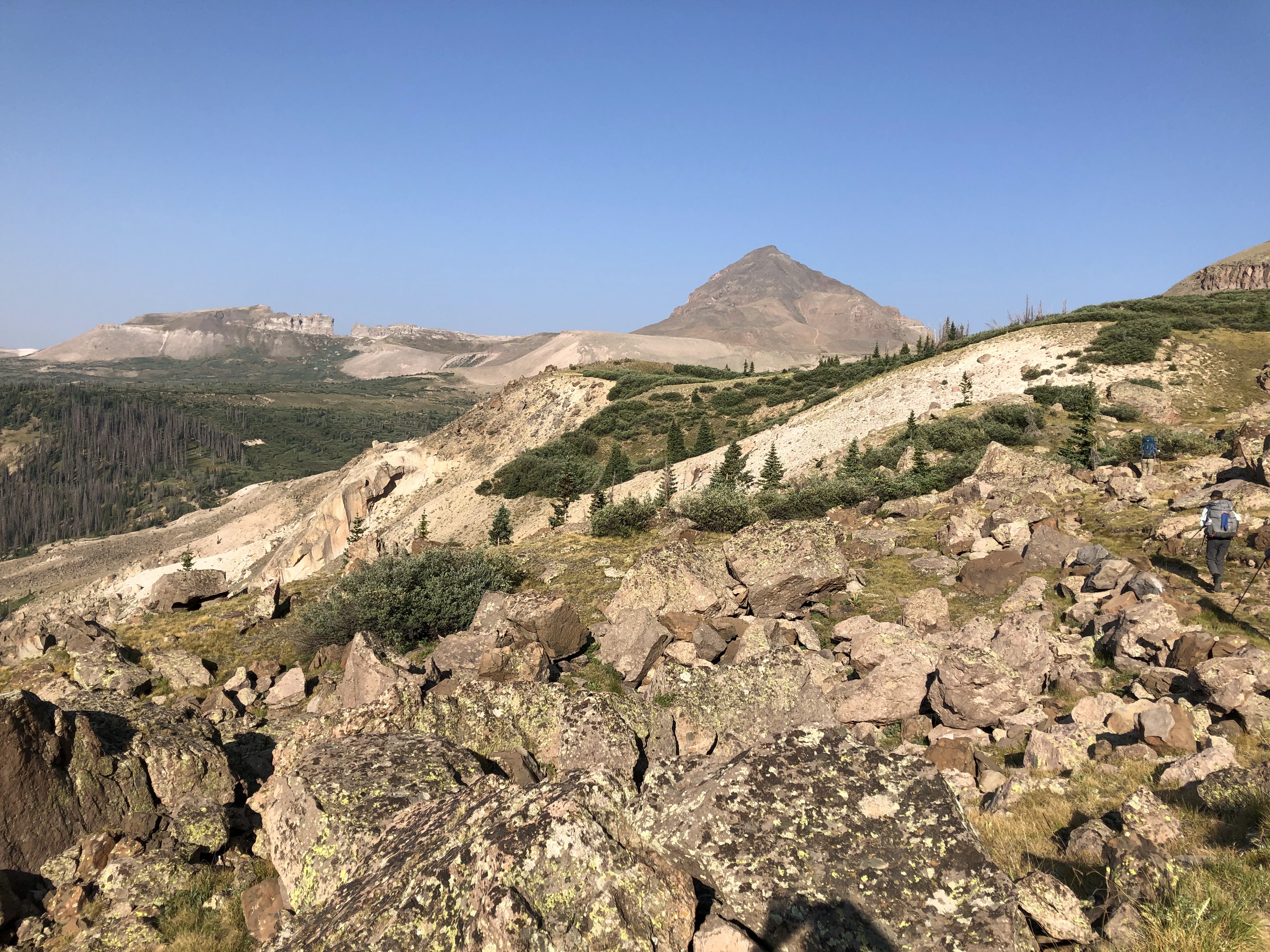
Next morning I hit the trail at the crack of dawn, ok it was 6:30, and continued to climb entering the Granite Peak Wilderness which offered yet another spectacular view. Shortly thereafter the TRT and the PCT separate and a long contour followed by a long descent through old-growth forest ensued.
View East From Granite Peak in the eponymous wilderness
I passed my last TRT trailhead along a dusty, hot forest road, climbed up another forest road and then contoured over a forested plain, Page Meadow, which obviously no longer was a meadow. There was significant mountain bike traffic on the trail, but with few exceptions the bikers were considerate. Slowly the signs of civilization being near increased and after a short steep descent I found myself by the side of the Truckee River, filled with rafters who apparently had not heard of covid, and than at the main intersection in Tahoe City.
After a delicious sandwich from a taco truck at the main intersection in town I caught the bus to Incline Village and made my way up Country Club Drive to SR 431, the highway to Reno. It was one stinking hot hike and I had not planned my water supply correctly! At the top I tried half-heartedly to hitchhike up to Oiphi Meadows, but this dirty dusty hiker had no luck. I was a bit more lucky with water by yogying some in the subdivision and then I hiked up the mountain bike trail that I had come down days earlier to pick up my car in Tahoe City. By 6:30 PM I reached my car and found everything in good order.
Coda
An hour later I found myself in Reno in a hotel, washing off ten days’ worth of grime, heading out to pick up a pizza and a few adult beverages. Alas, as I checked my email the hoped for permit for the SHR/SoSHR had not materialized in the interim. So this had not been an acclimatization hike after all. Nonetheless, I had had a good time. The Lake Tahoe area is really pretty (I know you were waiting for this blinding insight. I really try to add value) and not at all overdeveloped as I had feared (without having any specific reason for this fear) nor as overrun on a July Fourth weekend as one might have expected.
Overall it took me eight full days and two sort of half days and with the exception of one, from near Oiphi Creek to Spooner Lake, I did not really push it. Perfect hiking weather every day, blue skies and sunshine without it being too hot. Given the base altitude of the lake, you do not realize how high up you are most of the time.
The TRT is really suitable for a longer shakedown hike or a first through hike where the learning curve on all sorts of questions is steep. It is well signed and so you would get a freebie on the orienteering and can instead focus on other aspects of long distance hiking that you need to work out for yourself.
no clue what this is called.