In every walk with nature one receives more than he seeks
John MuirHow it all started
As fate would have it, one lazy Saturday afternoon I happened to be watching the videos that Jamal Green posts at AcrossUtah.com about his hikes in Utah over the past ten + years. After repeat watching the idea took hold that I should hike this route as my first major post-retirement project. I love the US Southwest, but up to that point I had only done road trips through that fascinating landscape, no hiking beyond hikes of a couple of days in Bryce and Zion NP.The route shares some mileage with the the Hayduke route, but omits, among others, the sections involving the Grand Canyon, which nicely fits my risk/reward calculation. My readings of reports by Haydukers have me scared of what the Grand Canyon asks of Hayduke hikers, particularly since I am a solo-hiker by preference. Some day, maybe, but right now I am not ready to sign up for this. For this reason the WASU route seemed just to be the ticket: I get to hike in the desert Southwest, it’s a route and therefore likely not overrun by 10,000 of my closest friends.
This write-up will have several parts. I will try to add value by providing some details I wish I had known before undertaking this hike while avoiding, as much as possible, overlap with the two existing reports on the WASU route I am aware of, by Amy Lauterbach/Jim Yurchenco (doingmiles.com) and by "No breadcrumbs” Paul Magnanti (pmags.com). While their reports lack detail, all were more than willing to answer specific questions I had via email.
Planning
Plans are useless but planning is indispensable.
General Dwight Eisenhower
Everybody has a plan until they get hit in the mouth.
Mike TysonOver the course of a year and half I spent about two months' worth of evenings and weekends planning this hike, going over maps and Google Earth over and over again, finding web resources and so on. I plotted my route on Gaia GPS and using some information from Google Earth. Let it be said right at the outset, however, that I am apparently not qualified to work as geospatial intelligence analyst. The real landscape rarely even remotely looked like the one I had imagined based on my interpretation of Goggle Earth imagery. With hindsight, revisiting on Google Earth some areas I passed through on the hike, I am now able to recognize features in the landscape that I did not recognize prospectively. Like everything else, interpreting satellite imagery is a skill that one can practice and get better or good at. It's just not as straightforward as you might expect. The part that is still particularly difficult is getting an idea of the slope of the terrain.
I had expected some deficiencies of the electronic topographic maps with USGS, USFS bases, say, owing to the fact that while obstacles in the terrain can be significant, say a 10 or 15 foot dryfall, they may not be significant enough to show up as a contour line in the base maps. Dealing with these unexpected obstacles is part of the fun, living by your wits.
The route takes you from the CO/UT border to the UT/NV border passing over the Lasal mountains, through Moab, across the fins above Moab, to Needles in Canyonlands NP, across the Colorado river, across Glen Canyon Recreation Area, across the Henry mountains, across Capitol Reef NP, across Escalante Natl. Monument, past or through Bryce NP, across Zion NP and across the Pine Mountains.
I chose to cache food, fuel and, in some places water, beforehand as towns and commercial opportunities are not close to the route between Moab and Escalante. As I expected to have to carry above average volumes of water for certain stretches, I wanted to keep food weight down in order to achieve a reasonable overall pack weight. Placing caches at Needles Outpost, Highway 95, Capitol Reef NP and above Mt. Carmel Jct. by Zion NP took me 2.5 days starting from Grand Junction, CO.
 |
| Cache in a side canyon off Swap canyon outside Capitol Reef NP |
I used this road trip also to visit the ranger offices in Canyonlands NP, Capitol Reef NP and the Interagency Office in Escalante to gather some information, get permits if possible. I’ll be discussing what I learned there below in the context of the appropriate section of the hike.
Taking a page from Amy and Jim’s playbook, I started my hike in Gateway, CO, a small hamlet in Unaweep canyon South of Grand Junction, CO on highway 141. A cab from downtown Grand Junction to Jct. US 50/CO141 South was $30 and within 30 min I had a ride to Gateway.
The plan was to cross the LaSal mountains from Gateway and I had planned out three alternative routes over this range depending on what the snow situation was going to be. This year (2019) the snow level was 3-fold that of a normal year. While I had been able to monitor the snow situation on the Moab side of the mountains online (https://moabgeartrader.com), all attempts to gather some information on the Unaweep side had come to naught (email to the Gateway fire station in the run up to the hike). On the day of the hike’s start neither the staff at the fire station nor the owner of the convenience store in Gateway knew anything firm about the conditions up top. I then decided to play it by ear. The routes I had planned out diverged at Taylor Flats, so the decision would be made there.
I ascended John Brown canyon on a 4x4 road and hit snow at around 7700 feet. There were tire tracks from 4 x 4 vehicles for about 200 yards and at the that point vehicles turned around as driving in the soft snow was too hard. It was immediately obvious that if I was going to be successful in crossing the Lasals, it was going to be by the most Northerly and lowest elevation route.
Figuring that the snow would be easier to navigate in the morning when it was cold, I camped by the side of the road, the dire threats of the land owners notwithstanding. Everything is posted up there, mostly I assume to keep hunters out as the area is littered with hunting lodges. Next morning the snow proved to be solid for about three hours and easy to walk on while wearing microspikes. Soon postholing commenced that varied between ankle- and knee-deep and progress was getting rather slow.
Gateway CO to Canyonlands National Park
I started my hike on April 15th 2019, late enough to make major snowfall en route unlikely (ha! sometimes your very reasonable expectations will not be met. This was one of them) and early enough to avoid June heat at the tail end of the trip. I also had lined up a trip to Alaska for the last week of June and immediately thereafter to France to finish off the Haute Route des Pyrenees. I needed to be back in order to get set for that next long trip.Taking a page from Amy and Jim’s playbook, I started my hike in Gateway, CO, a small hamlet in Unaweep canyon South of Grand Junction, CO on highway 141. A cab from downtown Grand Junction to Jct. US 50/CO141 South was $30 and within 30 min I had a ride to Gateway.
The plan was to cross the LaSal mountains from Gateway and I had planned out three alternative routes over this range depending on what the snow situation was going to be. This year (2019) the snow level was 3-fold that of a normal year. While I had been able to monitor the snow situation on the Moab side of the mountains online (https://moabgeartrader.com), all attempts to gather some information on the Unaweep side had come to naught (email to the Gateway fire station in the run up to the hike). On the day of the hike’s start neither the staff at the fire station nor the owner of the convenience store in Gateway knew anything firm about the conditions up top. I then decided to play it by ear. The routes I had planned out diverged at Taylor Flats, so the decision would be made there.
I ascended John Brown canyon on a 4x4 road and hit snow at around 7700 feet. There were tire tracks from 4 x 4 vehicles for about 200 yards and at the that point vehicles turned around as driving in the soft snow was too hard. It was immediately obvious that if I was going to be successful in crossing the Lasals, it was going to be by the most Northerly and lowest elevation route.
Figuring that the snow would be easier to navigate in the morning when it was cold, I camped by the side of the road, the dire threats of the land owners notwithstanding. Everything is posted up there, mostly I assume to keep hunters out as the area is littered with hunting lodges. Next morning the snow proved to be solid for about three hours and easy to walk on while wearing microspikes. Soon postholing commenced that varied between ankle- and knee-deep and progress was getting rather slow.
 |
| On Taylor Flats |
To boot the snow was heavily wind-blown and obscured the location and direction of the 4x4 road I was trying to follow. It was tough going without snow shoes. Fortuitously I hit on a snow mobile track created by somebody who presumably had checked on their hunting shack/lodge. Taylor Flat is pretty featureless, especially when covered in wind-blown snow. With a bit of experience one can discern how the road runs when one takes into account the preferred slope of a gravel road. As I was trodding along the snow mobile track it became apparent that the snow mobile driver not only followed the road when I checked by GPS, they even used the same track on their way out as on the way in, resulting in nicely compressed snow that was much easier to walk on. I would not have thought it possible, after all these years, but I had something good to say about snow mobilers. Go figure! I know they have a right to be there and I don’t think that walking/hiking is inherently superior to travel by means of a noisy mechanical contraption, but I still don’t like these things.
Anyway, eventually I hit the plowed, asphalted FS Rd. 207 (Castleton Rd) and descended until I reached public land that I could camp on in the bushes by the side of the road.
Next morning I continued to followed the road and the ascended the Lasal Loop Rd. towards Kokopelli’s Trail on the mesa above Moab. I collected water from snow melting by the side of the road until I reached the Mason Draw campground, which was deeply snowed in and not plowed. The eponymous spring is fenced off, presumably to keep the ATVers out. The exact location of the spring within that fenced-in area was not discernible under the deep snow. However, water appeared to drain down into the ditch by the side of the road and it was an easy, if frigid exercise to fill the bottles. (The Sawyer squeeze is really not the way to go to sterilize ice water!)
Kokopelli’s trail was deeply snowed in as well, the snow was soft and the postholing deep. The only other signs of human usage before me were a snow mobile track and a snow shoe track. After trying for a quarter mile I first beat a retreat back to the road where an outhouse by the side of the road provided some shelter from the frigid wind. After considering the low to nonexistent likelihood of getting a ride to Castle Valley and Moab from up there, I studied the map some more. It suggested that Kokopelli’s trail over its first mile descended slightly from where I was standing. Since I was not too far above the lower limit of snow coverage, there was a good chance that the snow would have melted at lower altitude along the trail. This turned out to be correct. After about half to three quarters of a mile of postholing through the snow and slush, the patches of mud grew larger and those covered by snow diminished in size and frequency. The walk turned from a struggle into an easy walk after about a mile. I camped under the cover of some pine trees near a power line and next day continued to Moab after having crossed Negro Bill canyon, a route first suggested by Amy and Jim. You can also follow the Porcupine Rim trail and descend down to the highway but you will have a long walk along a noisy and busy highway ahead of you.
There is not much camping for a hiker in Moab itself. Everything is geared towards car camping along the rivers and up on the mesa above Moab, which makes for long road walks to town, along busy highways, for those without vehicle. Positively not fun. There is one campground in town (Up the Creek) with about 20 sites. It’s not cheap and it lacks in charm and privacy, but for me it did the trick for one night. The place was fully booked when I arrived after dark but I lucked out in that a biker who had been abandoned by his mates allowed me to put up my tent on his site. I definitely recommend making a reservation rather than relying on luck. At this early stage of the hike it should be not too difficult to know exactly when you'll be in town and make your reservation accordingly.
I arranged for backcountry permits for Needles in Canyonlands NP online via recreation.gov (the rangers prefer it that way). The Tourist Information Office in town is useless, the people behind the counter don’t know anything and the NP office is 3.5 miles South of town, a nasty walk on the shoulder of a busy highway. The town library is close to the Tourist Information Office in a quiet side street off the main drag. There you can get internet access and print permits etc.. As usual the Micky D’s at the South end of downtown has fast wifi. Be aware that you need to have a physical copy of your permit with you. So if you organize your permit late, then you have to plan for a way of obtaining a hard copy. Lastly, be aware that the number of backcountry permits in Canyonlands NP per night is very limited (more on that later), so one should make one’s reservations, for this park specifically, way earlier than I did.
It turns out it was Jeep Jamboree Week in town, an annual event during the Easter week, which brings hordes of people to town and jeep safaris to the backcountry around Moab. If you can, avoid this week like the plague. I later heard that the town converted the municipal airport to an overflow campground to accommodate the traffic (this may be apocryphal I don't see an airport on the map). Motel rooms commanded prices that you’d be associating more with nice hotels in major urban centers.
I left town and headed for Cane Creek and the 4x4 road leading up to the fins. The road to the fins was closed for a Jeep Jamboree, but the "Stairmaster trail" for hikers was open. It was a hot ascent in the PM sun, but otherwise uneventful. At the top I was displaced from the road as 30 some odd jeeps, fully decked out and driven by men with peculiar tastes in beards left the backcountry. I went cross country according to my maps and learned then and there that I am really no good at interpreting Google Earth imagery. The land before me did not look remotely like what I had expected. But the walking was easy on sand and slick rock.
For some reason I could not make Jamal’s route as gleaned from his Google map work for me. I always ended up at a huge deep chasm that drained into Kane Creek down to my right.
Eventually I decided to find my own way. I climbed up on a major fin, for better visibility. I abandoned my pack and went along the spine of the fin looking for a spot from which I might glean “kidney bean mesa”, aptly so named after its appearance on high resolution maps. Eventually I got a glimpse of this landmark, retrieved my pack and then figured out a way to get there. The fins run in a principal NW to SE direction while your direction of travel is NE to SW, i.e. at right angles to the fins. These fins are up to several hundred feet high, so climbing over is not an option. You have to weave your way through the obstacle course. That late afternoon I got closer to the mesa, but not quite there, when I found a pocket of cold and clean water below a dryfall, which prompted me to call it a day.
To give you an idea of the scale of the fins: I heard voices behind me and saw two guys walking on top of a fin. From my vantage point it was evident that they would be running out of space as the fin ended abruptly. "Slow down!" I thought. The men sat down and I returned to the tasks ahead of me. A little later I hear a short yelp from behind me, turn around and just see a parachute disappearing behind my horizon. Seconds later the second guy makes a run for it and jumps into the abyss, his chute opens and he disappears. Cliff jumpers! What a way to get a thrill into your life!
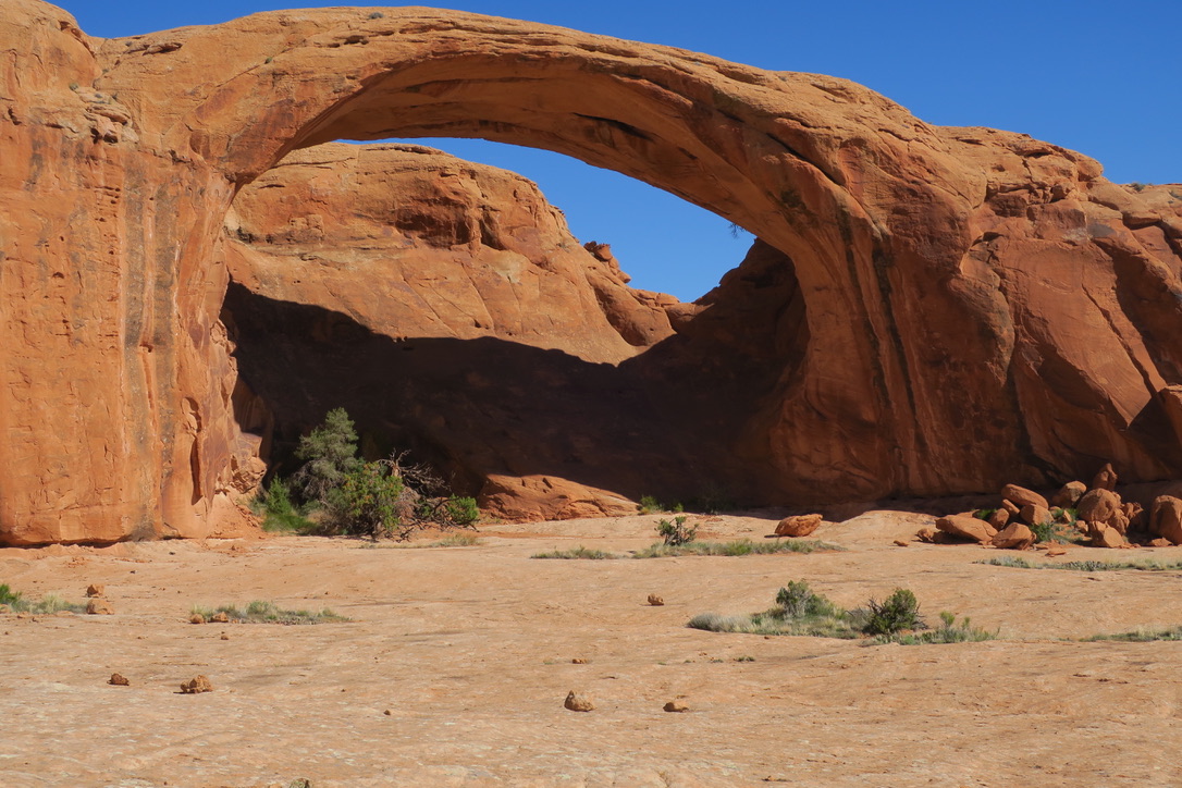
Next morning I climbed up on top of a long fin and walked all the way to the North end of it with the hope, not the expectation, that I might find a way to climb down from it rather than facing a smooth steep surface without foot and hand holds, and I got lucky! A little bit more back and forth and I chanced upon a use trail which led me to kidney bean mesa. I found a way off it and a steep climb down into the space between two giant fins led me to Pool Arch, a landmark I had hoped to hit. That gave me confidence that I was on the right track.
Anyway, eventually I hit the plowed, asphalted FS Rd. 207 (Castleton Rd) and descended until I reached public land that I could camp on in the bushes by the side of the road.
Next morning I continued to followed the road and the ascended the Lasal Loop Rd. towards Kokopelli’s Trail on the mesa above Moab. I collected water from snow melting by the side of the road until I reached the Mason Draw campground, which was deeply snowed in and not plowed. The eponymous spring is fenced off, presumably to keep the ATVers out. The exact location of the spring within that fenced-in area was not discernible under the deep snow. However, water appeared to drain down into the ditch by the side of the road and it was an easy, if frigid exercise to fill the bottles. (The Sawyer squeeze is really not the way to go to sterilize ice water!)
Kokopelli’s trail was deeply snowed in as well, the snow was soft and the postholing deep. The only other signs of human usage before me were a snow mobile track and a snow shoe track. After trying for a quarter mile I first beat a retreat back to the road where an outhouse by the side of the road provided some shelter from the frigid wind. After considering the low to nonexistent likelihood of getting a ride to Castle Valley and Moab from up there, I studied the map some more. It suggested that Kokopelli’s trail over its first mile descended slightly from where I was standing. Since I was not too far above the lower limit of snow coverage, there was a good chance that the snow would have melted at lower altitude along the trail. This turned out to be correct. After about half to three quarters of a mile of postholing through the snow and slush, the patches of mud grew larger and those covered by snow diminished in size and frequency. The walk turned from a struggle into an easy walk after about a mile. I camped under the cover of some pine trees near a power line and next day continued to Moab after having crossed Negro Bill canyon, a route first suggested by Amy and Jim. You can also follow the Porcupine Rim trail and descend down to the highway but you will have a long walk along a noisy and busy highway ahead of you.
There is not much camping for a hiker in Moab itself. Everything is geared towards car camping along the rivers and up on the mesa above Moab, which makes for long road walks to town, along busy highways, for those without vehicle. Positively not fun. There is one campground in town (Up the Creek) with about 20 sites. It’s not cheap and it lacks in charm and privacy, but for me it did the trick for one night. The place was fully booked when I arrived after dark but I lucked out in that a biker who had been abandoned by his mates allowed me to put up my tent on his site. I definitely recommend making a reservation rather than relying on luck. At this early stage of the hike it should be not too difficult to know exactly when you'll be in town and make your reservation accordingly.
I arranged for backcountry permits for Needles in Canyonlands NP online via recreation.gov (the rangers prefer it that way). The Tourist Information Office in town is useless, the people behind the counter don’t know anything and the NP office is 3.5 miles South of town, a nasty walk on the shoulder of a busy highway. The town library is close to the Tourist Information Office in a quiet side street off the main drag. There you can get internet access and print permits etc.. As usual the Micky D’s at the South end of downtown has fast wifi. Be aware that you need to have a physical copy of your permit with you. So if you organize your permit late, then you have to plan for a way of obtaining a hard copy. Lastly, be aware that the number of backcountry permits in Canyonlands NP per night is very limited (more on that later), so one should make one’s reservations, for this park specifically, way earlier than I did.
It turns out it was Jeep Jamboree Week in town, an annual event during the Easter week, which brings hordes of people to town and jeep safaris to the backcountry around Moab. If you can, avoid this week like the plague. I later heard that the town converted the municipal airport to an overflow campground to accommodate the traffic (this may be apocryphal I don't see an airport on the map). Motel rooms commanded prices that you’d be associating more with nice hotels in major urban centers.
I left town and headed for Cane Creek and the 4x4 road leading up to the fins. The road to the fins was closed for a Jeep Jamboree, but the "Stairmaster trail" for hikers was open. It was a hot ascent in the PM sun, but otherwise uneventful. At the top I was displaced from the road as 30 some odd jeeps, fully decked out and driven by men with peculiar tastes in beards left the backcountry. I went cross country according to my maps and learned then and there that I am really no good at interpreting Google Earth imagery. The land before me did not look remotely like what I had expected. But the walking was easy on sand and slick rock.
For some reason I could not make Jamal’s route as gleaned from his Google map work for me. I always ended up at a huge deep chasm that drained into Kane Creek down to my right.
 |
| Cane Creek from the fins above Moab |
Eventually I decided to find my own way. I climbed up on a major fin, for better visibility. I abandoned my pack and went along the spine of the fin looking for a spot from which I might glean “kidney bean mesa”, aptly so named after its appearance on high resolution maps. Eventually I got a glimpse of this landmark, retrieved my pack and then figured out a way to get there. The fins run in a principal NW to SE direction while your direction of travel is NE to SW, i.e. at right angles to the fins. These fins are up to several hundred feet high, so climbing over is not an option. You have to weave your way through the obstacle course. That late afternoon I got closer to the mesa, but not quite there, when I found a pocket of cold and clean water below a dryfall, which prompted me to call it a day.
To give you an idea of the scale of the fins: I heard voices behind me and saw two guys walking on top of a fin. From my vantage point it was evident that they would be running out of space as the fin ended abruptly. "Slow down!" I thought. The men sat down and I returned to the tasks ahead of me. A little later I hear a short yelp from behind me, turn around and just see a parachute disappearing behind my horizon. Seconds later the second guy makes a run for it and jumps into the abyss, his chute opens and he disappears. Cliff jumpers! What a way to get a thrill into your life!
Next morning I climbed up on top of a long fin and walked all the way to the North end of it with the hope, not the expectation, that I might find a way to climb down from it rather than facing a smooth steep surface without foot and hand holds, and I got lucky! A little bit more back and forth and I chanced upon a use trail which led me to kidney bean mesa. I found a way off it and a steep climb down into the space between two giant fins led me to Pool Arch, a landmark I had hoped to hit. That gave me confidence that I was on the right track.
 |
| Pool Arch |
While Jamal’s photos suggest that his route places him to the South of Pool Arch, I found myself to the North of it. However, I did know that Amy and Jim had found a way to get from where I was to the long corridor that Jamal used to get far to the Southeast end of the fins.
 |
| The corridor leading to the exit from the fins. |
After some poking around I found a suitable ramp down. Here, as on many occasions later, I learned that what you initially reject as “nuts to go down here” as you scope out potential routes, you will embrace as the “obvious way to go” after having evaluated the alternatives. After getting down to the bottom I uneventfully followed Jamal’s corridor, sticking mostly to its right bank. I found good water, which turned out to be important later in the day: the next two canyons are completely dry.

As the canyon opens up, it is important to get off the right bank and hang left, you’ll get cliffed out otherwise. Soon enough I found a way out of the end of the canyon, using ramps as Jamal has shown on his website. It’s kind of obvious and there are no misleading alternatives. I entered a new canyon that was altogether different than the one I had just left. The latter was narrow and all jumbled up with boulders that you had to wind your way around. The new one was wide, largely made of slickrock and easy to walk through. I drifted to the Southern wall as I headed in a Southwestern direction towards a towering rock next to a deep chasm. And then suddenly there was the “magic spot”, where you can climb out of the canyon via a small break in the Southern wall.
As the canyon opens up, it is important to get off the right bank and hang left, you’ll get cliffed out otherwise. Soon enough I found a way out of the end of the canyon, using ramps as Jamal has shown on his website. It’s kind of obvious and there are no misleading alternatives. I entered a new canyon that was altogether different than the one I had just left. The latter was narrow and all jumbled up with boulders that you had to wind your way around. The new one was wide, largely made of slickrock and easy to walk through. I drifted to the Southern wall as I headed in a Southwestern direction towards a towering rock next to a deep chasm. And then suddenly there was the “magic spot”, where you can climb out of the canyon via a small break in the Southern wall.
 |
| The "Magic Spot" as you leave the fins and enter the feeder canyon to Pritchett canyon. |
This break is covered, guarded if you will, by a pine tree that you have to squeeze by and some twenty steps later you find yourself in a feeder canyon to Pritchett canyon. A well used trail soon appears and you just walk out to the 4x4 road. This place is completely dry and pretty hot in the afternoon. Eventually you hit the jeep road and head Southeast. After some while the BLM directs the jeeps to climb out of the canyon towards the right. If you ignore the barrier and continue in the canyon you will hit within some 50 to 100 yards exposed rock with deep clefts that (may) harbor water that has not been contaminated by the jeep/ATV crowd. There were a few puddles by the side of the road along Pritchett Rd., but ATV/Jeep tire tracks going right up to or through them suggested that you’d be getting water tasting of rubber/motor oil if you drank that stuff. I continued further up the blocked-off canyon and spent the night there.
Next morning I followed the jeep road to the juncture with the road to Pritchett Arch. I left my pack under a pine tree by the side of the road and hiked up to the arch, first by way of a steep climb and then had a beautiful slickrock walk. I had the place entirely to myself.
Next morning I followed the jeep road to the juncture with the road to Pritchett Arch. I left my pack under a pine tree by the side of the road and hiked up to the arch, first by way of a steep climb and then had a beautiful slickrock walk. I had the place entirely to myself.
 |
| Pritchett Arch |
I continued along the road until I hit the road that runs above Cane creek on the mesa. I saw a few trucks with weekend campers and one of them stopped and made sure that I had enough water. I found more water in potholes on the rocky plain between the road and the cliff above Cane creek.
 |
| Pothole for collection of drinking water |
Eventually I reached the point where I had to descend from the mesa down to Cane Creek, about 450 ft vertical, opposite of Trough Springs canyon. I poked around and found two locations that looked kind of promising to start the descent. I settled on a point to the left of the slickrock bowl, looking out to Cane Creek, that allowed me to connect a bunch of ledges easily to reach the bottom of the bowl above the dryfall.
I climbed uneventfully through the maw of the dryfall, taking careful note of some deep dark holes between the big rocks. It is not difficult to imagine that one could fall into one of these rather easily and having a devil of a time of getting out once stuck in them. Take it slow and easy here. As I exited the maw of the dryfall I made a mistake. I got lured straight down by reasonable looking terrain in terms of slope which eventually turned into unreasonably steep and loose terrain. The right thing to do as you exit the maw of the dryfall is to head left along the base of the cliff towards a garage door-like looking light-colored patch of rock in the cliff, above a gully. Cross the rock-filled gully and you reach a grass covered dirt slope that is easy to descend. I eventually made it there but I wasted a good deal of time by not following what I now know to be the safest and straightforward way to get off that hillside. This is a problem only for the East to West hiker as you do not see whether there are cliffs down below where you are standing on the convex slope. A West to East hiker can see the entire slope from the bottom and pick the obviously correct route easily.
Jamal mentions that it is not easy to get to Trough Springs canyon. This was not at all my experience. After coming off the dirt hill I crossed the 4x4 road and entered one of the deep ditches that drain the plain below the mesa. The cows use this too, and as I often observe, the cows know how to get somewhere in the easiest, straightforward way. Follow the ditch to the creek and walk downstream some 50 yards at which point the creek splits. Take the left branch and climb out onto the far bank. After pushing through some tamarisk you will see a cow use trail and you follow it upstream. Soon a single track for XC motorcycles appears to your right. You also follow this upstream and then you come upon Trough Springs creek. Head upstream, climb to the left bank when you get a chance and soon you’ll hear the water gurgling down below to your left. After a short while there are opportunities to get down to the water. Last assured water for a good while, so plan carefully!
After camping in a pleasant meadow above the water, next morning I continued upstream until I found the trail that leads out of Trough Spring canyon (left bank of the creek). This a trail built by a local rancher family in the early 1900’s to drive cattle from Cane Creek to Hatch Mesa. It was restored in the 1980’s. It is easy to follow and climb, if steep. At the top you hit a parking lot and backcountry roads. A rather rough road leads you to Hatch Mesa campground. It being Easter weekend, the place was full, uncharacteristically as I learned later. There was a group of young families with hordes of little kids and dogs. One of the kids had asked for a camping trip for her birthday and that’s why all these people were there.
As I ascended the trail I had met a couple out day hiking, Leanne (sp?) and Landon from Glenwood Springs CO who invited me to put up my tent on their site and they’d feed me chili too when they returned. I spent the afternoon talking to an older Canadian couple, Jean and Lyle, who had deep connections to this place. From them I learned that typically this campground is empty around this time of year and that the water that Jamal talks about being available at the campground has never been on when this couple had been there. This is important because there is no water to be found until the bottom of Rustler canyon/Indian creek. So if you can’t get anything at Hatch mesa you must carry it up from Trough Springs canyon. Lockhart basin is bone dry and stinking hot!
Well fed and with 4L of water on my back I left Hatch mesa campground to find my way down to Lockhart basin. After a boring road walk I veered off the road eventually and came to the only spot that looked manageable to enter the slope. I did not find the most efficient route to get there, but I had a fantastic slickrock walking experience that made it all worthwhile. However, along the gravel road you walk from Hatch mesa campground there is a sign by the side of the road for an ATV trail to the right. I suggest that you take that, hang left when you can and work your way towards the cliff’s edge. The entry to the descent is pretty obvious, maybe 50 feet wide. To the left and right of this spot there are just very steep cliffs.


The cliffs above Lockhart Basin. There is exactly one spot you can get down!
The descent from Hatch mesa, about 1400 vertical feet, can be divided into three parts, the entry, the middle section and lastly the descent from the promontory, which you can see from the top, some 700 feet below (Jamal has good pictures on his site of this location). Definitely aim for that promontory, it’s the life saver here! The descent for the first 200 feet is straightforward, the middle section had me completely freaked out and the last third is easy-peasy. I became convinced in the middle that every rock on that hillside was out to murder or maim me. You test it out by placing some weight on it, it feels fine and as soon as you fully commit by stepping on it, it will give way. The slope is so steep that you can’t really see what’s below you. Sometimes the entire patch of dirt/scree/talus moves downhill with you “floating” on it and there’s nothing you can do. I found it harrowing and I did not think that I had a sufficient heads-up from Jamal’s description. Not that the pre-tightened sphincter helps all that much, but I was constantly asking myself whether I was missing the straightforward way again, as I had done the day before. Turns out I did not, it's just tough and there is no alternative. To this day I don’t know how I made it down, but eventually I did. Unlike the descent from the mesa above Cane creek, even in retrospect or inspecting it from below, the right way to get down this monster is not clear to me. Once you are on the promontory, you are golden. It’s straightforward to get to the basin bottom from there. Here again the West to East hiker has an advantage as they see where the cliffs are and can pick their route accordingly. The East to West hiker does not have the overview of the truly scary bits from above.
Lockhart basin was hot and windy and I went through water as if it were, well, water. The road climbs and winds and it is difficult to get a sense that one is making progress. Eventually I reached Rustler canyon and found a cow social trail to follow down into it. Rustler was completely dry as well and the many white potash deposits on the gravel suggested that drinking any water collected there might not be the smart move anyway. I dry camped and next morning continued on. Climbing through Rustler canyon dryfall is absolutely no probIem. I second Little Package (little-package.com) on this (she is the self-declared nut who did the Hayduke trail twice). There may even be some water on the ledge right below the chokestone, not the easiest to collect but may come in handy.
 |
| Descent to Cane creek |
I climbed uneventfully through the maw of the dryfall, taking careful note of some deep dark holes between the big rocks. It is not difficult to imagine that one could fall into one of these rather easily and having a devil of a time of getting out once stuck in them. Take it slow and easy here. As I exited the maw of the dryfall I made a mistake. I got lured straight down by reasonable looking terrain in terms of slope which eventually turned into unreasonably steep and loose terrain. The right thing to do as you exit the maw of the dryfall is to head left along the base of the cliff towards a garage door-like looking light-colored patch of rock in the cliff, above a gully. Cross the rock-filled gully and you reach a grass covered dirt slope that is easy to descend. I eventually made it there but I wasted a good deal of time by not following what I now know to be the safest and straightforward way to get off that hillside. This is a problem only for the East to West hiker as you do not see whether there are cliffs down below where you are standing on the convex slope. A West to East hiker can see the entire slope from the bottom and pick the obviously correct route easily.
Jamal mentions that it is not easy to get to Trough Springs canyon. This was not at all my experience. After coming off the dirt hill I crossed the 4x4 road and entered one of the deep ditches that drain the plain below the mesa. The cows use this too, and as I often observe, the cows know how to get somewhere in the easiest, straightforward way. Follow the ditch to the creek and walk downstream some 50 yards at which point the creek splits. Take the left branch and climb out onto the far bank. After pushing through some tamarisk you will see a cow use trail and you follow it upstream. Soon a single track for XC motorcycles appears to your right. You also follow this upstream and then you come upon Trough Springs creek. Head upstream, climb to the left bank when you get a chance and soon you’ll hear the water gurgling down below to your left. After a short while there are opportunities to get down to the water. Last assured water for a good while, so plan carefully!
After camping in a pleasant meadow above the water, next morning I continued upstream until I found the trail that leads out of Trough Spring canyon (left bank of the creek). This a trail built by a local rancher family in the early 1900’s to drive cattle from Cane Creek to Hatch Mesa. It was restored in the 1980’s. It is easy to follow and climb, if steep. At the top you hit a parking lot and backcountry roads. A rather rough road leads you to Hatch Mesa campground. It being Easter weekend, the place was full, uncharacteristically as I learned later. There was a group of young families with hordes of little kids and dogs. One of the kids had asked for a camping trip for her birthday and that’s why all these people were there.
As I ascended the trail I had met a couple out day hiking, Leanne (sp?) and Landon from Glenwood Springs CO who invited me to put up my tent on their site and they’d feed me chili too when they returned. I spent the afternoon talking to an older Canadian couple, Jean and Lyle, who had deep connections to this place. From them I learned that typically this campground is empty around this time of year and that the water that Jamal talks about being available at the campground has never been on when this couple had been there. This is important because there is no water to be found until the bottom of Rustler canyon/Indian creek. So if you can’t get anything at Hatch mesa you must carry it up from Trough Springs canyon. Lockhart basin is bone dry and stinking hot!
Well fed and with 4L of water on my back I left Hatch mesa campground to find my way down to Lockhart basin. After a boring road walk I veered off the road eventually and came to the only spot that looked manageable to enter the slope. I did not find the most efficient route to get there, but I had a fantastic slickrock walking experience that made it all worthwhile. However, along the gravel road you walk from Hatch mesa campground there is a sign by the side of the road for an ATV trail to the right. I suggest that you take that, hang left when you can and work your way towards the cliff’s edge. The entry to the descent is pretty obvious, maybe 50 feet wide. To the left and right of this spot there are just very steep cliffs.


The cliffs above Lockhart Basin. There is exactly one spot you can get down!
The descent from Hatch mesa, about 1400 vertical feet, can be divided into three parts, the entry, the middle section and lastly the descent from the promontory, which you can see from the top, some 700 feet below (Jamal has good pictures on his site of this location). Definitely aim for that promontory, it’s the life saver here! The descent for the first 200 feet is straightforward, the middle section had me completely freaked out and the last third is easy-peasy. I became convinced in the middle that every rock on that hillside was out to murder or maim me. You test it out by placing some weight on it, it feels fine and as soon as you fully commit by stepping on it, it will give way. The slope is so steep that you can’t really see what’s below you. Sometimes the entire patch of dirt/scree/talus moves downhill with you “floating” on it and there’s nothing you can do. I found it harrowing and I did not think that I had a sufficient heads-up from Jamal’s description. Not that the pre-tightened sphincter helps all that much, but I was constantly asking myself whether I was missing the straightforward way again, as I had done the day before. Turns out I did not, it's just tough and there is no alternative. To this day I don’t know how I made it down, but eventually I did. Unlike the descent from the mesa above Cane creek, even in retrospect or inspecting it from below, the right way to get down this monster is not clear to me. Once you are on the promontory, you are golden. It’s straightforward to get to the basin bottom from there. Here again the West to East hiker has an advantage as they see where the cliffs are and can pick their route accordingly. The East to West hiker does not have the overview of the truly scary bits from above.
Lockhart basin was hot and windy and I went through water as if it were, well, water. The road climbs and winds and it is difficult to get a sense that one is making progress. Eventually I reached Rustler canyon and found a cow social trail to follow down into it. Rustler was completely dry as well and the many white potash deposits on the gravel suggested that drinking any water collected there might not be the smart move anyway. I dry camped and next morning continued on. Climbing through Rustler canyon dryfall is absolutely no probIem. I second Little Package (little-package.com) on this (she is the self-declared nut who did the Hayduke trail twice). There may even be some water on the ledge right below the chokestone, not the easiest to collect but may come in handy.
 |
| Rustler canyon dryfall. Climb right on through! |
I could hear Indian Creek roaring from a quarter mile away, so there was no issue with supply of water this year. On Jamal’s site there are pictures of times when Indian Creek is dry and under those conditions you will find potholes at best to collect from.
I had my first encounter with quicksand there. As in others later, I was walking along on solid sand minding my own business and the next step, on “sand” that looks exactly like what you had just walked over, you go down and then have to extract yourself.
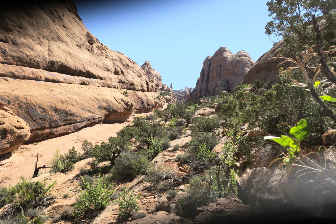
I found the place where the Haydukers leave Indian Creek and made my way to the top towards what I call the chocolate cliffs. These cliffs look like slices of chocolate layer cake, featuring all sorts of hues of brown in layers of varying thickness. In studying Jamal’s maps I had wondered why his route looked so convoluted through this area. Once I was there, it was clear why: the route is dictated by the landscape. The washes and canyons tell you where you can walk efficiently.
I had my first encounter with quicksand there. As in others later, I was walking along on solid sand minding my own business and the next step, on “sand” that looks exactly like what you had just walked over, you go down and then have to extract yourself.
I found the place where the Haydukers leave Indian Creek and made my way to the top towards what I call the chocolate cliffs. These cliffs look like slices of chocolate layer cake, featuring all sorts of hues of brown in layers of varying thickness. In studying Jamal’s maps I had wondered why his route looked so convoluted through this area. Once I was there, it was clear why: the route is dictated by the landscape. The washes and canyons tell you where you can walk efficiently.
 |
| Cross country above Indian Creek |
Eventually I reached “She-will-go” canyon and studied the various potential entry points. You see the first one and think “no way Jose”, the next one is worse, the third is even worse and so on. You return to the first and upon inspection you convince yourself that it can work, and it does. I pity the longitudinally challenged, though. You are now down about 15 feet in a slickrock bowl above a pour-off and the routine starts again. Explore options and identify the least bad. And, yes, you’ll make that one too and after that it’s a beautiful slickrock walk until you reach the bottom of the wash. After that it’s easy peasy. A dryfall provides water, and you leave the park to camp just outside of it. Next morning you reenter the park and continue. I suggest you take some side trips to your right to get a view of the Colorado river down below. There may be some water pockets there too. After a couple of hours you approach a feature that looks like another slice of chocolate cake, right next to a deep canyon coming in from the left. Your sphincter tightens as the canyon does not look climbable and you expect a similarly deep hole on the other side of the slice of chocolate cake and you reach the crest...... and it’s an easy step down, you see the Needles in the distance, then the road to Lower Jump, you made it through!
 |
| Just outside Canyonlands NP, Needles district |
The road walk is hot and dusty but eventually Needles Outpost appears in the distance on your left and shortly after you see the flag waving above the ranger station in the distance on your right. You head to the ranger station to pick up your permit and get to drink some cold water that you don't have to treat. What a treat!
The ranger on duty was very enthusiastic and helpful once I had told him what the plan was. This was a welcome change from the one I had encountered while placing my caches. The latter was mostly interested in charging me a fee for crossing the Colorado on packraft as I intended. He discouraged me strongly from hiking Lower Jump because of the cryptobiotic soil crust and strongly pushed the idea to walk the park road. This is completely nuts! There is a use trail around Lower Jump that you can see (even I can!) on Google Earth and the park road visits all sorts of locales before finally reaching the roundabout where the Overlook trail starts.
I headed over to Needles Outpost where I picked up my supplies and my packraft/paddle/life west, ate ice cream, had a Coke (one every decade on average for me) had a shower and camped in the “cave”.
Canyonlands NP
Next morning Bard from Needles Outpost gave me a ride to Big Spring overlook and I started my hike there. Thanks Bard! |
| The trail to Confluence Overlook is fun, up and down, hitting a variety of terrain on the way. |
The mixing of the waters of the Colorado and the Green river with their different colors was clearly visible.
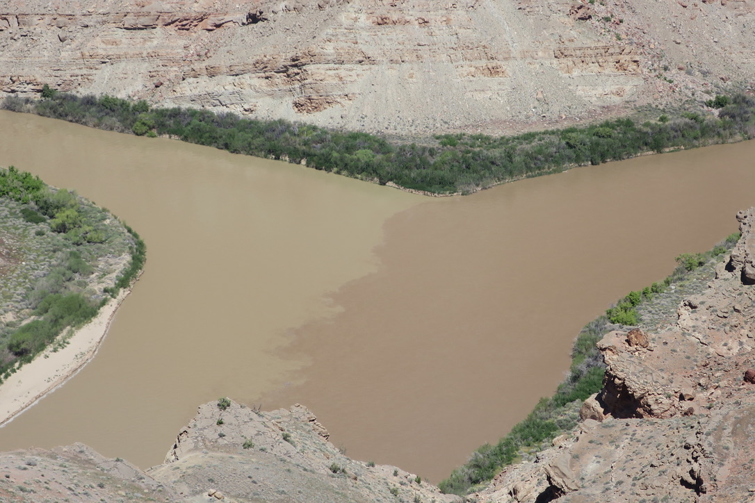 |
| Confluence overlook. The Green River (left) and the Colorado River (right) merge. |
I chickened out from the plan of descending the cliffs below Confluence Overlook, the route that Amy and Jim had taken down to the river. Part of that decision was owing to the additional 4 lb of weight from my packraft gear. I had also been advised that ropes had been removed from the slope and, not being absolutely sure whether ropes would be merely helpful or necessary to get down, I decided to not chance it. I later learned from Jim Yurchenco that they made it down without relying on the ropes. Instead I walked Hurricane canyon and the Red Lake canyon down to the river. Walking Hurricane Canyon was an eerie experience. The rocks to either side of the canyon are eroded in such a way that they look like long, grim faces, some 200-300 feet tall. I felt like a little hobbit walking along and Gandalf and his fellow wizzards looking down upon me disapprovingly.
 |
| In Hurricane canyon |
 |
| Red Lake canyon, Doll House in the distance |
As you reach the bottom upon exiting Red canyon, the water is well hidden from you by an impenetrable wall of vegetation, mostly tamarisk, a badly invasive brush all over canyon country. There must be a way to go a little in the downstream direction and reach the river because later on I saw people there. However, tired, hungry and parched, I was not successful in finding the correct way (it's obvious on Google Earth images if you plan ahead on going to that beach). I suggest you hike upriver, on the right as you exit Red Lake canyon, following a use trail in the grass. About half a mile upstream the vegetation is thinning out and you can get to the water at a rocky beach across from the upstream end of the Western shore of Spanish Bottom. Another 0.4 miles upstream gets you to a sandy beach even. I camped at the rocky beach for the night with the intention of crossing the river next morning.
That evening disaster struck in the form of my phone and power bank getting wet while charging. I had dosed off and apparently had toppled over a not completely closed water bottle, which I had foolishly kept on the same side of the sleeping pad as the phone/charger. What’s so infuriating about these screw-ups is that they are so easy to avoid. I know to keep my fuel bottle separated by my body from the stove when I light it. So why is it so hard to keep the water away from the phone which I know to be very sensitive to even a drop of water when it is not in its double ziplock bag (just not while charging!)? Weighing my options I decide to continue and make my way to Hanksville and organize a new phone from there. I was clearly not thinking straight. The right decision would have been to return to Moab, a much bigger town, relatively speaking, with more infrastructure than Hanksville.
That evening disaster struck in the form of my phone and power bank getting wet while charging. I had dosed off and apparently had toppled over a not completely closed water bottle, which I had foolishly kept on the same side of the sleeping pad as the phone/charger. What’s so infuriating about these screw-ups is that they are so easy to avoid. I know to keep my fuel bottle separated by my body from the stove when I light it. So why is it so hard to keep the water away from the phone which I know to be very sensitive to even a drop of water when it is not in its double ziplock bag (just not while charging!)? Weighing my options I decide to continue and make my way to Hanksville and organize a new phone from there. I was clearly not thinking straight. The right decision would have been to return to Moab, a much bigger town, relatively speaking, with more infrastructure than Hanksville.
 |
| The romance of entirely self-propelled travel across this land. Little did I know that the romance was soon to end. |
I inflated my packraft at the rocky “beach” and began the crossing. In Spring 2019 the river was several feet above its more typical water level. At the spot where I was crossing the river, it is relatively narrow and hence fast. Owing to high water levels there was quite a bit of debris cruising down the river, something to carefully check before you push off lest your raft gets hit by a tree trunk barreling down the river. Let me say right here that doing this with a canoe-type paddle is kind of difficult, a kayak-style paddle with two blades would be preferable. I had chosen the canoe paddle weight reasons, but this was a decision that falls under Andrew Skurka’s “stupid light” category. The current pushed me close to or into some “rakes”, trees that lean over the water with little space between the water surface and the bottom of the branches. Very unpleasant! Some 40+ years ago, under similar circumstances, I lost everything but the clothes on my back while paddling the Danube, behind the Iron Curtain no less, so I know firsthand how nasty these rakes can be.
The biggest and nastiest surprise, however, was the landing site at the downstream end of the Western shore at Spanish Bottom. I had interpreted the Google Earth image showing boats docked there as suggesting that there was a bay or beach. No such luck! As I approached the site it became clear that there was no hold to hang on to, just a steep bank of sand and dirt. Luckily there was a little bit of an eddie, so I did not have to work my tail off to just stay in place. The bay/beach turned out to be a level, bare area of sand and dirt some five feet above water level. How to get out of the packraft without dunking the pack? How to get the pack that far up the bank from a sitting position in the packraft?
I got lucky, which is always better than being merely good when the chips are down. Two Australian canoeists were waiting to be picked up by jetboat and they helped me greatly. I am not sure how I would have gotten out on my own, given the conditions. It turns out that at normal water levels there is a step in the bank that one can use to get out of the raft but in S’19 this was about six feet below the surface, even for someone my height impossible to reach.
The take home message from this ordeal is that if you travel East to West and wish to cross the Colorado river by packraft, you should use the sandy beach I mentioned earlier on the Needles side of the river to take off and you should aim to land at the upstream end of Spanish Bottom. Yes, the river is narrow and fast, but both getting in and out is easiest at these locations. If you travel West to East, you have it easy: you can push off at the upstream end of Spanish Bottom and cross over into a bay where Red Canyon runoff drains into the river. This bay is marked by a singularly tall Cottonwood tree. It is far inland but basically cannot be missed.

The biggest and nastiest surprise, however, was the landing site at the downstream end of the Western shore at Spanish Bottom. I had interpreted the Google Earth image showing boats docked there as suggesting that there was a bay or beach. No such luck! As I approached the site it became clear that there was no hold to hang on to, just a steep bank of sand and dirt. Luckily there was a little bit of an eddie, so I did not have to work my tail off to just stay in place. The bay/beach turned out to be a level, bare area of sand and dirt some five feet above water level. How to get out of the packraft without dunking the pack? How to get the pack that far up the bank from a sitting position in the packraft?
 |
| Omaha Beach on the Colorado. A rather difficult landing on the West shore at Spanish Bottom. |
I got lucky, which is always better than being merely good when the chips are down. Two Australian canoeists were waiting to be picked up by jetboat and they helped me greatly. I am not sure how I would have gotten out on my own, given the conditions. It turns out that at normal water levels there is a step in the bank that one can use to get out of the raft but in S’19 this was about six feet below the surface, even for someone my height impossible to reach.
The take home message from this ordeal is that if you travel East to West and wish to cross the Colorado river by packraft, you should use the sandy beach I mentioned earlier on the Needles side of the river to take off and you should aim to land at the upstream end of Spanish Bottom. Yes, the river is narrow and fast, but both getting in and out is easiest at these locations. If you travel West to East, you have it easy: you can push off at the upstream end of Spanish Bottom and cross over into a bay where Red Canyon runoff drains into the river. This bay is marked by a singularly tall Cottonwood tree. It is far inland but basically cannot be missed.

 |
| View from the West shore at Spanish Bottom towards Red canyon. Notice the tall tree in the center. |
For those not inclined to cross the river by packraft there is an alternative, Tex' Riverways of Moab, UT. They run a shuttle for rafters and canoeists who float the Green and/or Colorado river down to Spanish Bottom and shuttle them back by jetboat between Mar 1 and Oct. 31. Their website: info@texsriverways.com. As they pick up paddlers, they shuttle hikers across the river. I do not know whether for a fee, for a tip to the jetboat pilot or for a 10th round draft pick.
If you wish to make use of this service, you need to be down by the river by 10:30 AM. The jetboat does not necessarily run every day, so check with them well in advance. Be aware that there is no phone service (depending on your carrier, the phase of the moon and some other intangibles) up in Canyonland NP, let alone down at Spanish Bottom. There is supposedly one spot up by the Doll House where you can get some bars for ATT.
After climbing the straightforward trail from Spanish bottom to the Doll House and enjoying the scenery I headed over to Chimney Rock along a dry, sandy road.
 |
| Doll House (Canyonlands NP) |
 |
| In the Land of Standing Rocks: Chimney Rock |
It was hot and the wind was blowing fiercely. My mouth turned dry every ten minutes and I went through water like nobody’s business. At Chimney Rock I encountered a group of men from SLC who were out car camping and day hiking. They invited me under their shade cloth, gave me ice-cold water (Yes!) and asked me about my plans. As part of the conversation one of them offered to take my packraft/paddle/life vest and mail it to me. Can you believe this? Instead of having to lug this four pound parcel for another 150 miles, I could get rid of it half a day after I had used the gear. Thank you Drue, you are the best!
I took my leave and hiked along Pete’s Mesa as the sun went down. Incredible views and a fascinating slickrock walk. The descent into the Maze was steep and required a fair amount of scrambling but as the narrow drainage opened up at the bottom I found a nice at large campsite under a pine tree.

I hiked through the Maze in somewhat of a daze because of my stupid mistake two nights before. I made it out to the Mother and Child on the road that links Hans Flat ranger station to Standing Rock country. I camped off to the South of the road and spent some time that evening and next morning looking for the spring shown on the map South of the road. All in all I spent six hours looking for it, but did not find it. While at road level I could triangulate using my printed map/compass and obvious landmarks, as soon as I entered the canyons and washes below road level the landmarks disappeared behind the now very near horizon and triangulation was not possible any longer.
I learned another hard lesson here: my maps were, more or less arbitrarily, printed using an UTM grid. My Inreach mini emergency beacon used the default way of giving GPS location, degrees decimal minuted (DDM). Because of this mismatch in the way longitude and latitude were displayed between paper map and GPS, I could not use my Inreach to help me locate myself on the map. Inreach and printed maps need to use the same grid to display your location for true interoperability! It's easy to do, you just have to think of it in the first place, preferably before you find yourself in a pickle.
After six hours of this I called it quits and decided that continuing the joirney without GPS was irresponsible, that I should return to Moab and get a new phone. At this point I had a mere three oz of water left and four or five miles to walk to the only other water source known to me, at the bottom of Horse canyon in The Maze. It was hot and windy again, so this was not looking good. Luckily a group of young people from Boulder CO came driving by in their pick ups. I flagged them down and they supplied me with six liters of water, they had more than 100 on hand. One liter went down the gullet in short order and disappeared without a trace. Thanks guys, you saved my bacon!
I returned to Spanish bottom and rested until the jetboat came on Monday morning to pick up paddlers. I got a ride to Moab (in exchange for a small fortune) ~ 45 miles, very scenic, very NOISY. From the river I got a good look at the cliffs below confluence overlook, the route to the river taken by Amy and Jim. Looks eminently doable without the aid of ropes if you are patient in looking for the best way.
I had to wait for several days to get my Apple ID restored so that I could restore my apps and download my maps. There was also no availability of backcountry permits in the Needles section of Canyonlands NP until somebody were to cancel. At Up the Creek campsite I received many kindnesses from people who camped there who would allow me to share their campsite. Thank you Sam and Karen plus friends (Green River paddlers), and Ripsch! While there, one night a thunderstorm struck right above town. Within a few hours Moab received about a quarter of its annual rainfall in that one evening. The meek little creek behind the campground turned into a brown, raging torrent within minutes.
I was fortunate that so many people allowed me to share their sites and invited me to share dinner with them. I don’t know how I downed that tub of potato salad, Karen, but I ate every last bit of it! A son of my mother’s who would not allow any scrap of food go to waste. The Great Depression had been a harsh mistress for her as a kid.
By staying directly in town I could sort out my phone issues using computers at the library. Restoring an Apple ID takes a long time and it’s all done via AI and one gets to doubt the intelligence part of AI, but it is what it is. The problem is that I did not have a second “trusted device” with me that could receive an authentication code from Apple. This will require some attention in the future. There must be a way to overcome this hurdle. I had not had thought beforehand about this possibly being an issue.
Eventually, with the dedicated and generous help of the local computer store, Zen Tech, I took possession of a used phone and loaded back up the maps from Gaia. After four days I was ready to roll again! And just in time somebody cancelled their Canyonlands backcountry permit, the ranger gave me their slots, and the guys at Tex’ Riverways had a jet boat going down to Spanish bottom. The bad luck had decisively turned for the better!
Having returned to Spanish bottom I opted to continue my journey by hiking Ernie’s Country, a memorable hike along a very wide and long valley.


Fins in Ernie’s country in Canyonlands NP
I found the two springs that Ernie had modified with troughs to provide water for his sheep all those many years ago. One of them was the one I had been desperately looking for days earlier, before I returned to Moab. I now saw that I had been within 100 yards of it!
I took my leave and hiked along Pete’s Mesa as the sun went down. Incredible views and a fascinating slickrock walk. The descent into the Maze was steep and required a fair amount of scrambling but as the narrow drainage opened up at the bottom I found a nice at large campsite under a pine tree.

 |
| On Pete's mesa Canyonlands NP |
 |
| Descent to the Bottom of The Maze from Pete's mesa. |
I hiked through the Maze in somewhat of a daze because of my stupid mistake two nights before. I made it out to the Mother and Child on the road that links Hans Flat ranger station to Standing Rock country. I camped off to the South of the road and spent some time that evening and next morning looking for the spring shown on the map South of the road. All in all I spent six hours looking for it, but did not find it. While at road level I could triangulate using my printed map/compass and obvious landmarks, as soon as I entered the canyons and washes below road level the landmarks disappeared behind the now very near horizon and triangulation was not possible any longer.
I learned another hard lesson here: my maps were, more or less arbitrarily, printed using an UTM grid. My Inreach mini emergency beacon used the default way of giving GPS location, degrees decimal minuted (DDM). Because of this mismatch in the way longitude and latitude were displayed between paper map and GPS, I could not use my Inreach to help me locate myself on the map. Inreach and printed maps need to use the same grid to display your location for true interoperability! It's easy to do, you just have to think of it in the first place, preferably before you find yourself in a pickle.
After six hours of this I called it quits and decided that continuing the joirney without GPS was irresponsible, that I should return to Moab and get a new phone. At this point I had a mere three oz of water left and four or five miles to walk to the only other water source known to me, at the bottom of Horse canyon in The Maze. It was hot and windy again, so this was not looking good. Luckily a group of young people from Boulder CO came driving by in their pick ups. I flagged them down and they supplied me with six liters of water, they had more than 100 on hand. One liter went down the gullet in short order and disappeared without a trace. Thanks guys, you saved my bacon!
I returned to Spanish bottom and rested until the jetboat came on Monday morning to pick up paddlers. I got a ride to Moab (in exchange for a small fortune) ~ 45 miles, very scenic, very NOISY. From the river I got a good look at the cliffs below confluence overlook, the route to the river taken by Amy and Jim. Looks eminently doable without the aid of ropes if you are patient in looking for the best way.
I had to wait for several days to get my Apple ID restored so that I could restore my apps and download my maps. There was also no availability of backcountry permits in the Needles section of Canyonlands NP until somebody were to cancel. At Up the Creek campsite I received many kindnesses from people who camped there who would allow me to share their campsite. Thank you Sam and Karen plus friends (Green River paddlers), and Ripsch! While there, one night a thunderstorm struck right above town. Within a few hours Moab received about a quarter of its annual rainfall in that one evening. The meek little creek behind the campground turned into a brown, raging torrent within minutes.
I was fortunate that so many people allowed me to share their sites and invited me to share dinner with them. I don’t know how I downed that tub of potato salad, Karen, but I ate every last bit of it! A son of my mother’s who would not allow any scrap of food go to waste. The Great Depression had been a harsh mistress for her as a kid.
By staying directly in town I could sort out my phone issues using computers at the library. Restoring an Apple ID takes a long time and it’s all done via AI and one gets to doubt the intelligence part of AI, but it is what it is. The problem is that I did not have a second “trusted device” with me that could receive an authentication code from Apple. This will require some attention in the future. There must be a way to overcome this hurdle. I had not had thought beforehand about this possibly being an issue.
Eventually, with the dedicated and generous help of the local computer store, Zen Tech, I took possession of a used phone and loaded back up the maps from Gaia. After four days I was ready to roll again! And just in time somebody cancelled their Canyonlands backcountry permit, the ranger gave me their slots, and the guys at Tex’ Riverways had a jet boat going down to Spanish bottom. The bad luck had decisively turned for the better!
Having returned to Spanish bottom I opted to continue my journey by hiking Ernie’s Country, a memorable hike along a very wide and long valley.

Fins in Ernie’s country in Canyonlands NP
I found the two springs that Ernie had modified with troughs to provide water for his sheep all those many years ago. One of them was the one I had been desperately looking for days earlier, before I returned to Moab. I now saw that I had been within 100 yards of it!
 |
| The "flow" at one of the piped springs in Ernie's country |
After seeing the flow of these springs, in a wet year no less, the very tight limits on the number of permits for the Needles district made sense to me. The springs were running at about 0.1 fl. oz and 0.3 fl. oz/min, respectively. At this flow rate this land cannot provide enough water for more people and have something left over for wildlife. What looks at first glance like stingy and unduly restrictive regulation of the numbers of hikers allowed in the backcountry, makes a good deal more sense once you consider water supply. This the last reliable water until the bottom of Happy canyon.
 |
| Waterworks in Ernie's country |
Next I faced the Golden Staircase. When you see this cliff face from the road your sphincter tightens. The map suggests that you ascend the cliff some 0.6 miles West of the Mother and Child, climb some ways and then walk East high above the canyon floor in direction of the Mother and Child. How are you going to climb this wall and then do a horizontal walk in direction of the Mother and Child before climbing out on top? Seemed like a fantasy. The two bits of positive information I had were that this route had been used to drive sheep from Ernie's mesa to Moab and I have some idea from my childhood of what you can get sheep to do and what they won't. Second, this "path" was explicitly shown on Natl. Geographic maps, so it was not a cross country route proposed by someone with a risk tolerance much higher than mine.
Fear not! It's a complete nothingburger! As you start climbing you realize that what looks like a cliff face from the road is actually merely a steep slope and not a sheer face. The climb is well cairned if somewhat braided and as you start the horizontal portion you walk along a perfectly reasonable single track path that has just a few sketchy patches for a few steps, but nothing to be concerned about. As you approach the Mother and Child there is another steep ascent section to the mesa top. It is maybe not quite as straightforward as the first ascent portion, but you see clearly where you will be ending up and so you can improvise.
You cross China Neck and then walk a road that meets the road going from Hans Flat ranger station to the land of Standing Rocks. You also see ahead of you, dauntingly, the Flix Rd. That you will have to climb! This is a very steep, sandy road that by car can only be negotiated with a 4x4 vehicle and the requisite driver’s skills. It’s a tiring, hot climb on foot and you end up in the Orange Cliffs section of Glen Canyon Recreation Area which has fairly restrictive backcountry camping quotas. I had not been able to get a backcountry permit for the Maze/Needles and the Orange Cliffs section in succession, so I wild camped on the Gordon Flats (sorry, but there are only so many needles I can thread at one time). I camped in the bushes on top of the mesa and next morning I descended from the mesa down to Happy Canyon.
Happy Canyon initially did not make me very happy. That bloody wash really tried to demonstrate how to put the maximum number of zigzags into the length of the canyon. You walk at least two or three times the distance that a crow would fly from one end of the canyon to the other. It’s hot, rocky and mind-numbing. I also did not keep up with eating my snacks, so in late afternoon I was “hangry” and just plain old fed up. I pulled off to the side, camped under an overhang and slept off my foul mood.
Next morning I eventually reached the slot canyon and found a way to climb down into it. I had to admit defeat in short order because there were deep pockets of water below the dryfalls and I was not confident that I could climb out again should I encounter an insurmountable dryfall further downstream. I also could not persuade myself to climb into the slot further downstream. Never climb down what you are not confident to be able to climb up again!
 |
| Mother and Child with Golden Staircase in background |
 |
| Golden Staircase from below |
 |
| Mother and Child from on top of the Golden Staircase |
Fear not! It's a complete nothingburger! As you start climbing you realize that what looks like a cliff face from the road is actually merely a steep slope and not a sheer face. The climb is well cairned if somewhat braided and as you start the horizontal portion you walk along a perfectly reasonable single track path that has just a few sketchy patches for a few steps, but nothing to be concerned about. As you approach the Mother and Child there is another steep ascent section to the mesa top. It is maybe not quite as straightforward as the first ascent portion, but you see clearly where you will be ending up and so you can improvise.
You cross China Neck and then walk a road that meets the road going from Hans Flat ranger station to the land of Standing Rocks. You also see ahead of you, dauntingly, the Flix Rd. That you will have to climb! This is a very steep, sandy road that by car can only be negotiated with a 4x4 vehicle and the requisite driver’s skills. It’s a tiring, hot climb on foot and you end up in the Orange Cliffs section of Glen Canyon Recreation Area which has fairly restrictive backcountry camping quotas. I had not been able to get a backcountry permit for the Maze/Needles and the Orange Cliffs section in succession, so I wild camped on the Gordon Flats (sorry, but there are only so many needles I can thread at one time). I camped in the bushes on top of the mesa and next morning I descended from the mesa down to Happy Canyon.
 |
| View into Happy Canyon from the mesa. |
Canyonlands NP to Henry Mountains
There is an old road, a leftover from the Cold War era when this area was explored for uranium mining, that leads down into the canyon. Continue following the road. At some point the road will just be evident by a car-width opening between the trees. Eventually it will lead you into another wash. There is a somewhat chaotic section right at the entry where the water has destroyed what remains of the road. You see the bottom of the wash ahead of you below and you may be tempted to head straight down there. Don’t! Look to your left and you’ll see faint traces of the road covered by boulders. In the upper part the road bed is not very distinct, but once you go around the bend to your left it becomes well defined and a very easy walk. At the bottom there are even a few cairns and then you enter the wash of Happy Canyon.Happy Canyon initially did not make me very happy. That bloody wash really tried to demonstrate how to put the maximum number of zigzags into the length of the canyon. You walk at least two or three times the distance that a crow would fly from one end of the canyon to the other. It’s hot, rocky and mind-numbing. I also did not keep up with eating my snacks, so in late afternoon I was “hangry” and just plain old fed up. I pulled off to the side, camped under an overhang and slept off my foul mood.
Next morning I eventually reached the slot canyon and found a way to climb down into it. I had to admit defeat in short order because there were deep pockets of water below the dryfalls and I was not confident that I could climb out again should I encounter an insurmountable dryfall further downstream. I also could not persuade myself to climb into the slot further downstream. Never climb down what you are not confident to be able to climb up again!
 |
| Entrance to Happy Canyon slot canyon |
I then explored how my cow friends get down to the Dirty Devil, whose traces, aka cow pies and hoof tracks, I had seen all over the wash in Happy canyon. Clearly they did not climb the dryfall. Sure enough there is a cow trail on the left side of the slot canyon that leads down to the river. Alas the trail ends at what I call "Dead Cow butte", some 200 feet above the river. Like my bovine friend I felt somewhat deflated myself when I saw this, but I was not yet quite ready to lay down and die.
 |
| I was not ready to quit quite yet as this bovine had |
Looking downstream I saw a ramp reaching down to the river, but upon inspection found the top a bit too sketchy to reach for my taste. I also saw the foot of a slope as the river was bending out of sight that was mostly obscured by a cliff facing me.
I climbed the cliff and coming over the top on the other side found two ridges that went down to the river. I chose the one featuring a cow path. After crossing the river multiple times I made it to the entry of the slot canyon from the Dirty Devil side. I dumped the pack and hiked the slot. One of the visually most stunning sights I have ever seen in my life! It was early afternoon and the sun was high overhead. The canyon is like a cathedral with the light being reflected back and forth from the walls as it reaches down. My photography skills are no match for the sight.
 |
| Dirty Devil river, ramp down in the middle (not taken) and cliff above climbed to reach a ramp down to the river. On the opposite side of the river is the cliff I was to walk across to Poison Springs Rd. a few hours later. |
I climbed the cliff and coming over the top on the other side found two ridges that went down to the river. I chose the one featuring a cow path. After crossing the river multiple times I made it to the entry of the slot canyon from the Dirty Devil side. I dumped the pack and hiked the slot. One of the visually most stunning sights I have ever seen in my life! It was early afternoon and the sun was high overhead. The canyon is like a cathedral with the light being reflected back and forth from the walls as it reaches down. My photography skills are no match for the sight.
  |
| Happy Canyon slot canyon |
Continuing on, upstream from the slot on the the opposite bank of the Dirt Devil is a weakness in the canyon wall and that’s where you will find a faint trail that will allow you to climb up. It’s steep and loosely cairned. Eventually and suddenly you step onto an old road bed, another cold war uranium exploration relic. You walk the road bed in a downstream direction, high above the river. It’s an easy walk to the end of Poison Springs Road where I camped for the night.
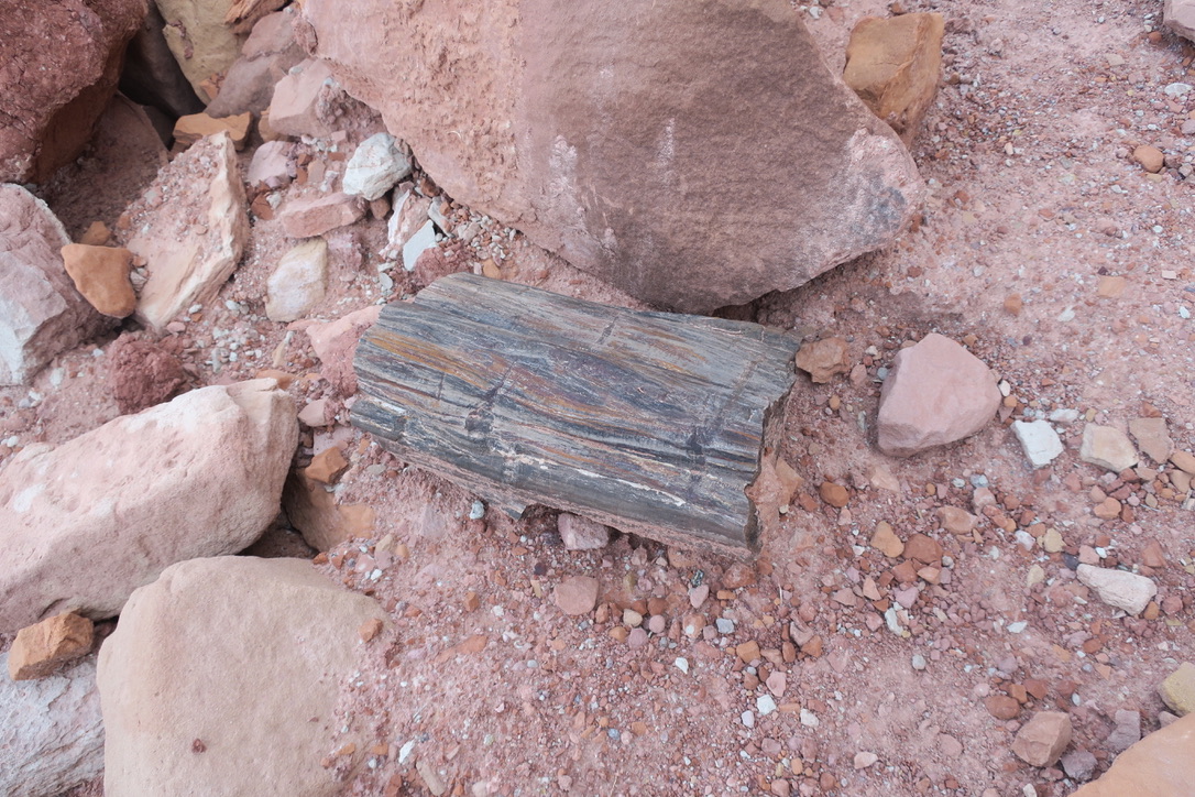 |
| Petrified wood |
Next day I walked Poison Springs Road out to highway 95. There is a nice spring on the right side of the road at the bottom of a cliff. You’ll find the site by watching for water running across the road and along it, coming from the right. Exiting from the canyon you find yourself on a featureless plain and it’s a bit of a challenge to identify the correct 4x4 road to walk out to the highway, which you can’t see. After some back and forth I found Poison Springs Road and my food cache.
The ferkackte “microbears”, aka mice, had gotten into it and eaten everything that contained a nut. At least they left the Ramen and the jerky in peace after tasting it, so I had something to make dinner with. However, rations for the next few days were going to be short. It was a cold and windy night with little shelter for the tent. Looming above me were the snow-covered Henry mountains, the next cause for sphincter tightening. How bad was the snow going to be, considering the recent precipitation?
The ferkackte “microbears”, aka mice, had gotten into it and eaten everything that contained a nut. At least they left the Ramen and the jerky in peace after tasting it, so I had something to make dinner with. However, rations for the next few days were going to be short. It was a cold and windy night with little shelter for the tent. Looming above me were the snow-covered Henry mountains, the next cause for sphincter tightening. How bad was the snow going to be, considering the recent precipitation?
 |
| View of the Henry mountains from highway 95 |
Next morning I hit the road and walked the highway down to the juncture with Crescent Springs Rd., which I then climbed. Bad weather was looming in the near distance, deeply black clouds with curtains of precipitation dropping out of them, curtains of water so thick that they completely obscured the landscape behind them. At higher elevations the system dumped snow.
I got off the road three times and took cover under pines or junipers as the downpour closed in repeatedly. Eventually, at about 7.5 k feet I had enough of this game, put up my tent and shortly thereafter the thunderstorm finally struck where I was, rather than all around me.
Next morning was sunny and I continued my climb up the road and then headed for Pennellen Pass. The sun did not last long and at about 8k feet I got snowed on. Around that altitude I also hit the clay layer. This bentonite clay sticks to the rubber of shoes (and tires) and you walk on pads of clay clinging to the bottom of your shoes. Sometimes the front of the pad falls off while clay continues to stick to your heel, so you are walking as if wearing high heels. Next it’s the other way round, the front of the pad sticks and the pad under your heel falls off. Next the whole pad falls off. It’s like walking on stilts while somebody constantly adjusts the height of the foot rests by remote control to mess with you. Very tiring, very hard on the knees.
Eventually, the snow turned into rain and that eventually stopped too. The sun came out and I had a pleasant walk down Pennellen Pass. I found Aircraft Spring and the pipe providing cool clean water below and behind the enclosure. The descent was steep along a 4x4 road, but entirely unproblematic. I camped at the bottom on Kings Ranch Road by a creek. I had scoped out a route across the Henry peaks as well which would have necessitated a cross country descent to King Ranch Road, but the snow up on the peaks deterred me. I did not have microspikes with me any longer, let alone an ice axe, and the scars from crossing the Pyrenees in deep snow the year before were still quite fresh on what goes for my soul.
Next morning I started the descent, only to run into Robert who was hiking Jamal’s route in the opposite direction. We exchanged some water and route information and went our separate ways. Jamal’s description of the Tarantula mesa descent is spot on. There are a few sketchy
spots, some of which I don’t know how the longitudinally challenged (aka short) people get over. With my long legs, no problem. The view back from the bottom is nothing short of amazing.
All these towering cliff faces all around you and then there is this one spot with a fifteen foot wide chute that allows you to get down.
 |
| Severe weather during ascent of Henry mountains. |
Next morning was sunny and I continued my climb up the road and then headed for Pennellen Pass. The sun did not last long and at about 8k feet I got snowed on. Around that altitude I also hit the clay layer. This bentonite clay sticks to the rubber of shoes (and tires) and you walk on pads of clay clinging to the bottom of your shoes. Sometimes the front of the pad falls off while clay continues to stick to your heel, so you are walking as if wearing high heels. Next it’s the other way round, the front of the pad sticks and the pad under your heel falls off. Next the whole pad falls off. It’s like walking on stilts while somebody constantly adjusts the height of the foot rests by remote control to mess with you. Very tiring, very hard on the knees.
Eventually, the snow turned into rain and that eventually stopped too. The sun came out and I had a pleasant walk down Pennellen Pass. I found Aircraft Spring and the pipe providing cool clean water below and behind the enclosure. The descent was steep along a 4x4 road, but entirely unproblematic. I camped at the bottom on Kings Ranch Road by a creek. I had scoped out a route across the Henry peaks as well which would have necessitated a cross country descent to King Ranch Road, but the snow up on the peaks deterred me. I did not have microspikes with me any longer, let alone an ice axe, and the scars from crossing the Pyrenees in deep snow the year before were still quite fresh on what goes for my soul.
Henry Mountains to Escalante
The next day did not start well when I woke up to rain. As I packed up I noticed that I had lost one of my gloves between Aircraft Spring and the Kings Ranch Road which necessitated a climb up the road for 45 min until I found the damn thing. I then climbed Tarantula mesa, finding some good water at the first catchment system by the side of the road. The later, solar-powered system was entirely dry and appears to be defunct. At the end of the road I took off to the left to find the “Magic Spot” (Little Package), the weakness in the cliffs supporting the mesa. The walking cross country across the mesa was tedious, climbing over dead tree limbs left behind from a chain clearing exercise from many years ago. Eventually, I started to see cairns in the area where I expected to find the entry to the descent route. I set up the tent and explored the entrance to the route. Looked reasonable right at the chute, to the left and right not so much. |
 |
| View of Tarantula mesa right across from the “Magic Spot”. |
Next morning I started the descent, only to run into Robert who was hiking Jamal’s route in the opposite direction. We exchanged some water and route information and went our separate ways. Jamal’s description of the Tarantula mesa descent is spot on. There are a few sketchy
spots, some of which I don’t know how the longitudinally challenged (aka short) people get over. With my long legs, no problem. The view back from the bottom is nothing short of amazing.
All these towering cliff faces all around you and then there is this one spot with a fifteen foot wide chute that allows you to get down.
 |
| The"Magic Spot" from below. You come down through the chute in the center |
In the picture above, taken after the descent, you can see the entry to the "Magic spot" at the horizontal bit on the left on the horizon. You make it down to the level of the top of the "bulwarks" and traverse left (in direction of travel). You then come down the chute shown in the center of the picture and finish off by negotiating the mud slope, which is considerably steeper than the photo suggests.
At the bottom I opted for the classical Hayduke route to Swap canyon rather than Jamal’s alternative since I had not downloaded my notes for this alternative when I restored my phone in Moab and I had no hard copy. The canyons below Tarantula mesa are so convoluted that as a solo hiker I did not feel like winging it, the next water being at Swap canyon where I had cached four liters. It was reasonably straightforward to find the use trail and the “bison crumbs” (bits that fall out of the Northern end of a South-facing bison) helped as well. I did not see any bison, it was too late for that, but their route to the meadows in Canyonlands and around Swap canyon were clearly marked with their droppings.
Eventually I made it to my cache in a side canyon off Swap canyon and found it intact. Phew! I camped just outside the barrier that closes off Capitol Reef NP to the bison.
Next morning I crossed over to and climbed the Burr Rd, then followed the 4x4 road that leads to the parking lot at the bottom of the Strike Valley overlook. What a fantastic view down to this gash running for some 110 miles through the landscape! I encountered a group of hikers from the PNW and we played tag for a while. I then followed the trail along the top of the ridge towards the Northwest with Upper Muley Twist canyon on my left and the waterpocket fold on my right. A very pleasant slick rock walk with some up and down, over and under stretches thrown in. A steep descent to a ledge above Upper Muley Twist canyon and a convoluted trail down to Shy Arch followed. Atypically, there was a lot of water in Upper Muley Twist canyon.
At the bottom I opted for the classical Hayduke route to Swap canyon rather than Jamal’s alternative since I had not downloaded my notes for this alternative when I restored my phone in Moab and I had no hard copy. The canyons below Tarantula mesa are so convoluted that as a solo hiker I did not feel like winging it, the next water being at Swap canyon where I had cached four liters. It was reasonably straightforward to find the use trail and the “bison crumbs” (bits that fall out of the Northern end of a South-facing bison) helped as well. I did not see any bison, it was too late for that, but their route to the meadows in Canyonlands and around Swap canyon were clearly marked with their droppings.
 |
| Maze of canyons below Tarantula mesa |
Eventually I made it to my cache in a side canyon off Swap canyon and found it intact. Phew! I camped just outside the barrier that closes off Capitol Reef NP to the bison.
 |
| Waterpocket fold Capitol Reef NP |
Next morning I crossed over to and climbed the Burr Rd, then followed the 4x4 road that leads to the parking lot at the bottom of the Strike Valley overlook. What a fantastic view down to this gash running for some 110 miles through the landscape! I encountered a group of hikers from the PNW and we played tag for a while. I then followed the trail along the top of the ridge towards the Northwest with Upper Muley Twist canyon on my left and the waterpocket fold on my right. A very pleasant slick rock walk with some up and down, over and under stretches thrown in. A steep descent to a ledge above Upper Muley Twist canyon and a convoluted trail down to Shy Arch followed. Atypically, there was a lot of water in Upper Muley Twist canyon.
 |
| In Upper Muley Twist canyon |
I camped in the side canyon directly by Shy Arch that I would be climbing out of next morning to reach Onion flats. Jamal describes this well. The bottom of this side canyon is boulder choked, but not too bad. If you then climb steeply in the dirt to the right you eventually reach the ridge. There is another canyon on the other side of the ridge and I opted to climb down all the way to the right to a rump near the far wall. This rump guided me up to the next ridge in completely uncomplicated fashion. Eventually I stepped out from the pine and juniper forest onto the Onion Flats Rd. which I followed to the North. There was a well-filled stock tank with cool water, I replenished my supplies and I continued on. The course of the road you walk there makes no sense on the map. When you are there it becomes obvious why the road runs the way it does: there are deep channels cut into the land for flood waters to drain and the road simply tries to get around them. If you set out on your own cross-country you would be running into them. These things are deep, 10-15 feet, and have very steep banks. If you walked up close to the edge and the dirt gave way under you, this would be very unpleasant.
Eventually I reached the Lampstand and found the water works Jamal mentions on his site. Alas, I did not get the clear, champagne-like water from the water works I was promised. What I got was Château Deux Chevaux, my term for road run-off. In the present case it was of deeply red color with some bovine turd floaters, like a crappy Rose. I was outraged and demanded my money back! Alas there was nobody to listen to my complaints. Alum settled out most of the red solids and eventually I got decent water after filtration and sterile treatment.
 |
 |
| Waterworks at the Lampstand. Rose on valve lid, defunct catchment in the middle and cattle tank in back |
For those too young or for other reasons not familiar with the Citroen Deux Cheveaux, the iconic student car of the 1970's and 80s in Europe, here you go:

I continued on the road all the way to where I camped below a mesa I would have to climb next morning. Another day with parching sun and a blow-drying wind.
Next morning I climbed up to the mesa on an old prospecting road. It was not going to be my day. After making my way up the old road I just followed the remains of the road right in front of my nose, without realizing that there was a maze of old roads and that I needed to take my time and pay attention. After fixing this bad orienteering error that cost me two hours and a few unnecessary miles, I eventually found the road that was supposed to lead me to Egg canyon. Alas in orienteering error II of the day, I latched onto the old road bed that runs along Long canyon. By the time I checked on the GPS after what I saw in front of me did not match the description I remembered, I was so far down Long canyon that I could not be bothered to climb back up and make it over to Egg canyon. I followed Long canyon all the way to the Burr Road. The hitchhiking at first did not look promising, little traffic and all in the wrong direction. Eventually I was picked up by Lexie, a young exploration geologist on her way from Georgia to an internship in Nevada. We had lunch at the Burr Trail Cafe and continued on to Escalante. Thanks Lexie!
My original hiking plan had been to walk down Egg canyon, make it to Lower Gulch trailhead and then to climb onto the mesa overlooking “The Gulch” with the ultimate goal of reaching Boulder Creek and walking it out to the Escalante River and then to Escalante town. When stepping into the Escalante Interagency Office while I was placing caches, the ranger I talked to made a face when she heard of this plan. She advised strongly against it, both from a water level and water temperature point of view, given that it had been a wet Spring. Having hiked this stretch this Fall, this was absolutely the right advice. Thanks Jean!
 |
| Boulder Creek in Fall. Look at the waterline on the rocks to the left. |
It is not that one is irreversibly committed once one starts this section, but one easily loses a day or two retracing one’s steps if it turns out that that the water is indeed too high. And the dangerous temptation is, of course, to power on in order to avoid wasting time. And to then get into trouble! The water sure is very cold in Spring and you walk through it for hours! Based on the ranger’s advice (which I heeded! I am getting old and meek) I was going to cut out this section between The Gulch and Escalante and that is how it turned out.
I had planned a ZERO in Escalante and I needed it! I stayed at the Escalante Outfitters campground. Shower, laundry, post office, eating, more eating, some adult beverages, permits at the BLM Interagency office for the next section to Bryce. As I discussed my plans for the walk over to Bryce ranger Jean gave me another good piece of advice concerning Round Valley Draw slot canyon. The winter had been wet, so I might be slow in making my way through the slot canyon. The weather forecast was not great and you for sure don't want to be in a slot canyon when it is raining. She advised I bypass Round Valley Draw slot and enter Hackberry canyon from above via a use trsil at the end of the slot canyon. After she had been so dead on with her first advice re Boulder creek, how could I ignore this one? I was going to take this under advisement and burn the bridge once I was going to reach it.
Eventually you hit a site where gas is being pumped out of the ground and from then on you walk a dirt road. Owing to rain the previous night, the road was a mess and I struggled to make it up the hills in the muck. Soon enough it was bentonite clay time again, walking with a couple of pounds of muck clinging to my shoes. I ran into a young Canadian couple who were doing Jamal’s route in the opposite direction. They had been struggling with similar conditions for hours. So we told each other that the misery would continue for each of us and parted ways.
At Mossy Dell I found some decent water in an earthen tank. The first tank right where the road passes was dry, but passing along it further down you come into a green oasis that also has the tank in it. from there you work your way up a Forest Service road that runs along a ridge.
It had been my plan to make my way from Blue Wash to Headquarters Wash via the "Jamal Ridges", a route pioneered by Jamal but not so named by him, I am sure. I first encountered this term in a caltopo map online of the area area around Escalante town. The Canadians had told me that they had tried it and found that "Jamal Ridge" is a knife edge ridge impossible to pass under wet conditions, the muck being so slippery. So I had a “heads up”, but when the point came to leave the ridge road to head over to Jamal Ridge, I would not have known how to get down to the base of it. The steep dirt slope I would have had to descend to get over to the ridge seemed as slippery as the comparatively flat dirt road I was on.
Reluctantly I resigned myself to a road walk along FS Road 313 and then 441 to Grosvenor Arch, labeled the "Skurka route" in the caltopo online map, probably from Andrew Skurka's Hayduke guide. It took for bloody ever and there was no traffic to hitch a ride, nor was there any water until I crossed Blue Wash. A passing BLM paleontologist who was going to his dig site gave me an updated weather report and that did not sound great: rain and cold temperatures for the next week or so.
Eventually I made it to Grosvenor Arch and the stock tank nearby which solved my water problem. I also got a ride from two guys from VA to the road leading to Round Valley Draw. They gave me more water, clean to boot, and they insisted on taking my garbage! When you run into real hikers, they know your real concerns! Thanks guys!
I had planned a ZERO in Escalante and I needed it! I stayed at the Escalante Outfitters campground. Shower, laundry, post office, eating, more eating, some adult beverages, permits at the BLM Interagency office for the next section to Bryce. As I discussed my plans for the walk over to Bryce ranger Jean gave me another good piece of advice concerning Round Valley Draw slot canyon. The winter had been wet, so I might be slow in making my way through the slot canyon. The weather forecast was not great and you for sure don't want to be in a slot canyon when it is raining. She advised I bypass Round Valley Draw slot and enter Hackberry canyon from above via a use trsil at the end of the slot canyon. After she had been so dead on with her first advice re Boulder creek, how could I ignore this one? I was going to take this under advisement and burn the bridge once I was going to reach it.
Escalante to Bryce
After a pleasant stay in Escalante I departed one overcast and cold morning heading for Death Ridge (the oldtime locals really did have a way with names, I have to say). The cold wind made me opt for Horse Spring canyon instead of hiking the more exposed ridge. Jamal mentions Horse Spring canyon, but apparently has not hiked it. It’s pleasant enough and in sunny weather could be downright pretty. In windy rainy weather it’s a bit of a slog through the sometimes sandy, sometimes rocky wash with fewer sights to keep the boredom at bay. Like upper Happy canyon, maybe. Rocky, hard on your feet, endless zigzags of the wash as it meanders within the canyon.Eventually you hit a site where gas is being pumped out of the ground and from then on you walk a dirt road. Owing to rain the previous night, the road was a mess and I struggled to make it up the hills in the muck. Soon enough it was bentonite clay time again, walking with a couple of pounds of muck clinging to my shoes. I ran into a young Canadian couple who were doing Jamal’s route in the opposite direction. They had been struggling with similar conditions for hours. So we told each other that the misery would continue for each of us and parted ways.
At Mossy Dell I found some decent water in an earthen tank. The first tank right where the road passes was dry, but passing along it further down you come into a green oasis that also has the tank in it. from there you work your way up a Forest Service road that runs along a ridge.
 |
| "Jamal Ridges" |
It had been my plan to make my way from Blue Wash to Headquarters Wash via the "Jamal Ridges", a route pioneered by Jamal but not so named by him, I am sure. I first encountered this term in a caltopo map online of the area area around Escalante town. The Canadians had told me that they had tried it and found that "Jamal Ridge" is a knife edge ridge impossible to pass under wet conditions, the muck being so slippery. So I had a “heads up”, but when the point came to leave the ridge road to head over to Jamal Ridge, I would not have known how to get down to the base of it. The steep dirt slope I would have had to descend to get over to the ridge seemed as slippery as the comparatively flat dirt road I was on.
Eventually I made it to Grosvenor Arch and the stock tank nearby which solved my water problem. I also got a ride from two guys from VA to the road leading to Round Valley Draw. They gave me more water, clean to boot, and they insisted on taking my garbage! When you run into real hikers, they know your real concerns! Thanks guys!
 |
| Grosvenor Arch |
Everybody with a car was trying to leave the backcountry before the roads became impassable owing to impending bad weather. I took this as an indication that I should heed ranger Jean’s advice and not hike the Round Valley slot canyon and take the bypass to Hackberry canyon instead.
 |
| Entrance to Round Valley Draw slot canyon |
This I did next morning after loading up on water in the seep in the Round Valley area. The bypass runs along the Round Valley Draw slot in the upper part. The trail then climbs up on top of the mesa on the right where it braids out badly and becomes difficult to follow in places.
At some point I crossed a gully and continued on faint trail on the other side. Eventually I found myself atop a major canyon coming in from the right that could not be climbed and likely not be walked around. Apparently I was a good distance off the purported location of the descent route to Hackberry canyon. What had I missed? I walked back, mystified as to how I was going to find the entry to the descent. It turns out that the gully I had crossed earlier was the entrance to the descent! The first cairn at the top is just located too low down. Once you think “Screw it, I’ll try this” you are off to the races. The gully is narrow and very steep, but within 15 min you are at the bottom. No drama. The cairning at the bottom is much better for the people doing the slot canyon and then return to the trailhead via the bypass.
At some point I crossed a gully and continued on faint trail on the other side. Eventually I found myself atop a major canyon coming in from the right that could not be climbed and likely not be walked around. Apparently I was a good distance off the purported location of the descent route to Hackberry canyon. What had I missed? I walked back, mystified as to how I was going to find the entry to the descent. It turns out that the gully I had crossed earlier was the entrance to the descent! The first cairn at the top is just located too low down. Once you think “Screw it, I’ll try this” you are off to the races. The gully is narrow and very steep, but within 15 min you are at the bottom. No drama. The cairning at the bottom is much better for the people doing the slot canyon and then return to the trailhead via the bypass.
 |
| Round Valley Draw bypass |
So if you do Round Valley slot canyon you can hardly miss the site where you are supposed to climb up and out to return to your vehicle.
 | ||
|

Hackberry canyon is fantastic and in the few moments that the sun was out, it really glowed. While I was told it was dry for the first eight miles, it actually rained most of the time. I was outraged and felt like getting my money back. But there was again nobody to accept my complaint! I thought we live in a service economy! What’s up with that?
When water started to flow in the canyon bottom it was a modest flow, maybe two fingers’ width of depth and three feet wide. While taking a break on one of the banks I heard a strange noise and it turned out that there was a flash flood in the sandy creek bed I had been walking in only minutes earlier. The creek was now 12-15 feet wide and two feet deep, the water flowing at what seemed the speed of light and lots of floating debris. No way was I going to walk that, remembering my earlier experience with quicksand in Indian Creek and also not being sure whether the canyon was going to narrow downstream to a box canyon without banks. In the end I was stuck in this location for more than a day until the waters started to recede. A couple of miles further downstream I found the entry to Stone Donkey canyon, my exit from Hackberry canyon.
When water started to flow in the canyon bottom it was a modest flow, maybe two fingers’ width of depth and three feet wide. While taking a break on one of the banks I heard a strange noise and it turned out that there was a flash flood in the sandy creek bed I had been walking in only minutes earlier. The creek was now 12-15 feet wide and two feet deep, the water flowing at what seemed the speed of light and lots of floating debris. No way was I going to walk that, remembering my earlier experience with quicksand in Indian Creek and also not being sure whether the canyon was going to narrow downstream to a box canyon without banks. In the end I was stuck in this location for more than a day until the waters started to recede. A couple of miles further downstream I found the entry to Stone Donkey canyon, my exit from Hackberry canyon.
 |
| Entrance to Stone Donkey canyon |
Stone Donkey canyon was a little paradise: a modest flow of clean water, an easy walk under an overhanging cliff, only one minor obstruction fairly early on and then an easy walk across sand and rock. I walked up to the slot canyon, checked it out and then looked for the spot where one climbs out to Upper Death Hollow. My first attempts were stymied until I saw cow tracks on the left bank which proved to be the ticket out. My bovine friends guided me out in straightforward fashion and I soon found myself up on the shelf near Cottonwood Peak.
Jamal’s route traverses the slickrock between the slot canyon on one side and Cottonwood Peak on the other. He labels this traverse as “sketchy” and I was keen on finding an alternative. Considering that the prior difficult passages had not earned any special “heads up” mention, when he says ”sketchy” about this passage, I was ready to avoid that. I put up my camp under a pinion tree fairly high up by Cottonwood Peak and explored how I might proceed next morning.
I saw rolling folds of terrain behind the peak and felt confident that a non-sketchy alternative was at hand. Next morning I crossed behind Cottonwood Peak and then started a descent over slickrock down to the rocky plain above Stone Donkey slot canyon.
 |
 |
| Upper Death Hollow above Stone Donkey canyon |
It went fairly straightforward at first, but then I had to descend one last steep slickrock face that in the middle gave me more problems than I had anticipated at the top, specifically a layer of very crumbly yellowish sandstone that just did not want to provide a solid foot hold. After trying to get around this layer at other spots I finally screwed up my courage and in not very elegant fashion, meaning on my butt, I crossed this band of sand and made it down. In the end I don’t think my route is less sketchy than I suppose Jamal’s to be, and it surely is not faster. It seems possible that if one walks further to the Northwest from Cottonwood Peak than I had done, that the descent is less steep and therefore less challenging. For another day!


Above Stone Donkey slot canyon.
For the next few hours I crossed Lower Death Hollow, a very pleasant and easy walk across rolling hills with spectacular scenery in the distance to keep the mind occupied. The wildflowers, most specifically the iris, were spectacular even though I only saw the early bloomers. The peak iris bloom would likely happen a few days after my passage. Eventually I ended up in a dry stream bed that I followed down towards Sam Pollock arch.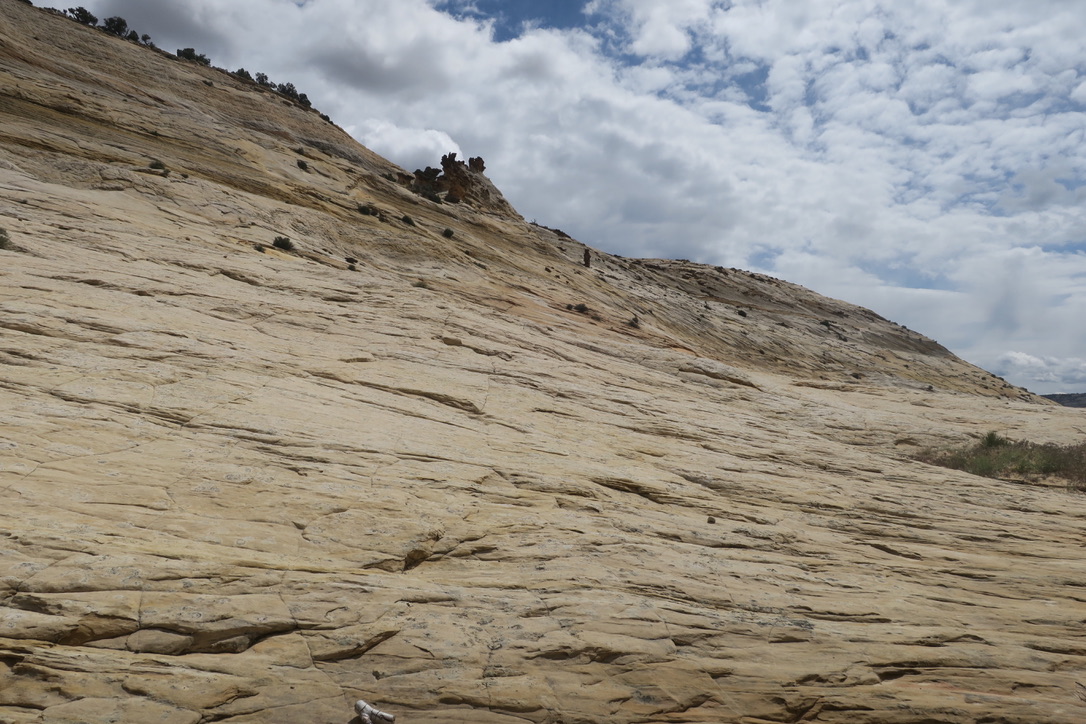
 |
| Sam Pollock arch |
An easy slickrock walk with minor dryfalls that were easy to navigate. With the arch in sight the dryfalls become larger, but the overland route to the arch out of the stream bed is obvious. After poking around the arch and a light lunch I took aim towards Hogeye canyon, which was to lead me to the Pariah. The easiest and fastest way I perceived was to walk back up the creek-bed I had just come down. At a bifurcation I took the left branch which led me easily to within sight of the ridge that separates Hogeye canyon from Lower Death Hollow. After consulting the map I aimed for the right side of Hogeye canyon as there was a creek-bed that goes down that canyon.
 |
| Ridge above Hogeye canyon |
Since thie strategy of following stream beds had worked so well all morning, I thought I’d just continue. It started easy enough, great slickrock walking, some potholes with good water (very timely) and then I found myself suddenly cliffed out! What the hell? After poking around a bit I found that the canyon has a cleft within its upper reaches and that I needed to be on the other side of said cleft.
 |
| Cleft through back of Hogeye canyon |
There appeared to be no reasonable way to cross over to the other side from where I was, so I had to climb up what I had just come down. From my present vantage point I could see how I might get down to the canyon floor once on the other side of the cleft. Some 100 ft below the crest I had come across earlier there is a horizontal use trail that leads one above the cleft to the cliffs on the left side of the canyon (looking downcanyon) and from there it is a steep and loose descent towards a chimney-like structure. Next to this chimney is a dryfall that one can choose to descend if one has one’s chimney moves on. I opted to climb down a rockwall right above the cleft. I thought this was easier than the dryfall, but the spot has significant exposure: you are standing right above the depths of the cleft and if altitude is not your thing, my way of getting down should not be yours! Then comes a second dryfall below the chimney which is straightforward to climb through. As you exit you immediately see how the further journey is going to go: climb out to the left and use ramps between the pine trees to reach the canyon floor. Easy-peasy!
Jamal, walking in a West to East direction, does not mention the cleft since it is completely obvious, from the bottom, how to ascend the back of Hogeye canyon. It is only the East to West hiker who has to know which side to go as the cleft in the canyon is not visible from the ridge top.
What follows as you walk out Hogeye canyon is just marvelous! The canyon narrows and widens as you go along, beautiful red rock scenery, some negotiating of minor dryfalls. In the middle section of the canyon there are some narrow sections in which big Cottonwood trees grow, competing for light. Not a photon gets wasted here, no trace of sunshine reaches the canyon floor, every bit of sunlight gets harvested by the trees. Sheer beauty!
About a mile from the Pariah there are two obstacles to overcome, a logjam and a rockfall. After a bit of trial and error the hiker will find a straightforward way to overcome both. I camped on the bank above the Pariah in a grove of mature cottonwood trees. Good thing I stocked up on water in Hogeye canyon shortly before exiting since the Pariah is almost as murky as the Dirty Devil.
Next morning I walked up the Pariah river, crossing it 34 times ( I could have saved myself a few crossings, but not a significant number). The water was cold enough that I imagined hearing the clinking of ice crystals, but not really. In any case my feet were not on speaking terms with me for the rest of the day.
 |
| Pariah river |
Luckily, the deepest the water ever got was about mid-calf. The day was mostly overcast and so the rock of the canyon wall did not glow as it would have on a sunny day. It was a workman’s day: get it done! At the top of the Pariah river I chose to walk up Willis gulch where I crossed the stream more than 30 times before exiting at the trailhead which was completely deserted.
The hiking plan was to go to Cannonville PO, pick up a resupply package and then walk Skutumpah Rd towards Glendale bench. As I reached the dirt road it was raining fairly steadily and it had apparently done so for a while. There was just me and some grumpy cows boredly chewing the cud in the fog and rain. Skutumpah Rd was a muddy, slippery mess and within five minutes I looked as if I had mud-wrestled with a pig and had enjoyed myself. Eventually I pulled off to the side of the road, put up my tent, cooked some dinner and got into my bag, working to reconnect with my numb feet. It rained on and off all night and consequently next morning the road was in even worse shape than it had been the night before. I eventually reached the top of a steep hill and I could see down below the road leading to Cannonville in the distance. A rancher apparently had driven the cows down the hill in front of me and I could see how the animals had slid and slipped on the road. I soon followed in their tracks and carefully descended towards the road. It is a rare occurrence that I welcome walking a blacktop road, this morning was one of them!
Soon the town limit sign of Cannonville appears, but no sign of human settlement. Some fancy houses, second homes or homes of people who have retired here, but still no sign of “downtown”! Eventually a truck with three young people stops and offers a ride. Yeah! They have some major artillery in the cab and it turns out that they are coming back from target shooting. They drop me off at the PO. The postmistress has a hard time finding my parcel, but remembers to have seen it. After some phone calls she tells me that the parcel had been sent back already as the maximum hold time had been exceeded. Damn, not my day! The postmistress even offers to go to her house and get me some foodstuffs to tie me over. How sweet! But that’s taking the relying on the kindness of strangers a bit far. I recall that there is a supermarket/store in Tropic up the road, so I decide on the spot to go to Tropic, take a NERO, dry myself out, clean myself up and weigh my options.
I pass by the Cannonville BLM office where my good friend ranger Jean happens to be on duty, good fortune on a not so great day. I receive a status report on the Skutumpah Rd. (Washed out in places and impassable), the legality of camping off the road (illegal, private land). I need to plan on camping since in the present state of the road I don’t think I can reach Glendale bench in one day. The plan had been to start early and to push the entire 30 miles along the road in one day. Not too much of a reach when the road is dry and the weather not too hot, but these conditions are not on display today or in the forecast for the next few days. So Tropic it is! Jean even offers to drive me over there on her lunch break, the second generous offer I receive this day, but I opt for the road walk. It’s seven miles to the town border and then another two to reach “downtown”, all three blocks of it. The woman running the coffee shop has a good reputation as "hiker friendly" amongst Hayduke hikers and that’s where I head. She only has the King George suite available in her motel, in exchange for a minor fortune. But she directs me to the right place and also knows the laundromat with a utility sink where I can pre-wash my clothes before loading them in the washing machine.
She also explains to me the odd placement of town signs along the highway: it’s the towns’ way of fighting against the “encroachment”, as seen by the locals, of Bryce NP and the Escalante Natl. Monument. Even though these small towns would not have an economy to speak of were it not for the park or the monument and the visitors they bring, they resent the feds with a passion. Same in France around the Parc Nationale des Pyrenees. It’s not just an American thing, or a US West thing, or a Utah thing. It's mostly about maintaining a style of life, whether economically viable by contemporary standards or not. Paul Magnanti has a good write-up on this phenomenon in this area of the country on his website (Edit: I did not remember this quite right. Paul had a review of a documentary about the fight around Bears Ears (https://pmags.com/review-battle-over-bears-ears-documentary) and reviews of/thoughts on two books on this and related topics (https://pmags.com/review-desert-cabal-by-amy-irvine and https://pmags.com/some-thoughts-brave-new-west). Thanks to Paul for providing these links). I am certainly familiar with it from the area that I grew up in, very far from Tropic, UT.
I soon have the use of a warm room to dry and clean my gear, to put on my poncho over my Merino pants (my laundry day uniform), and I make progress towards cleaning the hiking clothes. I splurge on pizza and beer and soon find myself in a mentally better place. The plan is to cut out the Cannonville/Tropic to Mt Carmel section and instead to hitchhike over there.
Within ten minutes I am being picked up by a group of four young Poles who have been traveling in the US for the first time (for three of them). They are heading to Zion as the last stop on their journey before returning home. They have a campsite reserved in the park and invite me to share the site with them. Today is my lucky day! This gives me an opportunity to figure out the situation on the Virgin River and the permit for the crossing of Zion to Kolob canyon.
Time flies when you are having fun and sometimes also when you don’t. This is Memorial Day weekend, the busiest day of year in Zion! According to my original hiking plan I would long have been done, but that’s not quite how the cookie crumbled. Anyway, a back country permit is not to be had for money or good words. Forget about the sites that are supposedly “walk-up”. On the busiest weekend of the year that’s out the window. Also “The Narrows”, the East fork of the Virgin River, a hike I did with three friends 25 years ago, is closed, the river running at eight times normal flow rate and a water temperature of 38F. This means that the North fork is likely going to have similar conditions and will not be passable for me at this time. In fact, in Escalante I met a Hayduke hiker who reported that he had nearly been swept away in the North Fork of the Virgin river a few days earlier. So, no, this stretch of the hike goes on the chopping block too.
The best the Zion backcountry office can do for me is to issue me an “at large” permit for the East Rim and then they will look into finding a solution for the West Rim hike for me once the long weekend is over.
The original hiking plan had envisioned coming up from the North fork of the Virgin river at Checkerboard Mesa, to cross over to the East rim and hike down to the main Zion canyon, cross it and then go up to the West Rim. Turns out that there had been a major rockslide and the descent from the East Rim to the Zion canyon bottom is closed. It is not only that you have to cross the debris field, a talus hike, so no big deal, but they are also very concerned about the stability of the remaining rock face. There could be a second rock avalanche and that’s why they are strict about the closure. Alas, the closure is so poorly communicated to the hiking public that I think they would have a hard time making their $$$ fines actually stick. But who needs the headache, especially when this section of the trip is messed up in other ways too?
So I stay with my new Polish friends. We hike up to Angels Landing, together with 10,000 of our closest friends. But the view from the top at sunset is nothing short of stunning! Just too damn many people who don’t know what they are doing on the ridge. The top is surprisingly peaceful, the scenery is majestic and the condors are playing in the updraft.
Next day I go for a dayhike in an area of the park located between Springdale and Rockville. I have the place to myself pretty much. My Polish friends hike the West Rim in two pairs going in opposite directions and swapping car keys in the middle. For the evening we plan a traditional American opening of the barbecue season and we’ll have steak and fire roasted potatoes and onions. And so it happened. Eventually.
Next morning I take my leave from my Polish friends to go to the East rim and they return to LV where Kate’s father lives to return the truck and to make their way back to Poland. I get a ride to the East gate very readily and spend my day poking around in the backcountry of the East Rim. I spend the night at Deertrap mountain where I freeze my butt off, get snowed upon and in the morning hike out in about 2” of wet snow. I visit the site of the lumber cable car high above Zion canyon where an enterprising lumber baron had installed said cable car to ferry logs from the plateau on the East Rim down to Zion canyon. A neat feat of engineering, but there was just not enough lumber to harvest, so economically not as successful.
I hike out to the road in partially sunny weather and get a ride down to the visitor center from an avid hiker who is really interested in my journey and in learning how to build up the skillset to be able to do something similar. The backcountry office can give me two nights at established sites on the West Rim starting the next day. Alas, there is no camping available at South campground in the park, all sites are booked, if unoccupied, and there is no way to assign a reserved site that is not used to another person. Not a good situation if you are on foot, without car, but it is what it is.
Eventually I locate a private campground in Springdale that has a car camping site available, for a minor ransom, and so that’s where I end up. I put up my tent to dry out and resupply in town. The prices are steep, but I only need food for three days, so what. As I cook my supper the occupant of the neighboring site returns from her day hike and we chat a bit, ending up sitting by the fire drinking beer and chatting about life for most of the night. She’s from Georgia and has flown to Zion to spend her birthday away from home.
Next morning I leave at the crack of dawn to catch the first shuttle bus for the ride to the West Rim trailhead, which is coincident with the Angels Landing trailhead. In 45 min I make my way up to where the two trails separate and for the next two hours I enjoy a fabulous and blissfully solitary slickrock walk. It’s so good to leave all these people behind!
The hiking plan was to go to Cannonville PO, pick up a resupply package and then walk Skutumpah Rd towards Glendale bench. As I reached the dirt road it was raining fairly steadily and it had apparently done so for a while. There was just me and some grumpy cows boredly chewing the cud in the fog and rain. Skutumpah Rd was a muddy, slippery mess and within five minutes I looked as if I had mud-wrestled with a pig and had enjoyed myself. Eventually I pulled off to the side of the road, put up my tent, cooked some dinner and got into my bag, working to reconnect with my numb feet. It rained on and off all night and consequently next morning the road was in even worse shape than it had been the night before. I eventually reached the top of a steep hill and I could see down below the road leading to Cannonville in the distance. A rancher apparently had driven the cows down the hill in front of me and I could see how the animals had slid and slipped on the road. I soon followed in their tracks and carefully descended towards the road. It is a rare occurrence that I welcome walking a blacktop road, this morning was one of them!
Soon the town limit sign of Cannonville appears, but no sign of human settlement. Some fancy houses, second homes or homes of people who have retired here, but still no sign of “downtown”! Eventually a truck with three young people stops and offers a ride. Yeah! They have some major artillery in the cab and it turns out that they are coming back from target shooting. They drop me off at the PO. The postmistress has a hard time finding my parcel, but remembers to have seen it. After some phone calls she tells me that the parcel had been sent back already as the maximum hold time had been exceeded. Damn, not my day! The postmistress even offers to go to her house and get me some foodstuffs to tie me over. How sweet! But that’s taking the relying on the kindness of strangers a bit far. I recall that there is a supermarket/store in Tropic up the road, so I decide on the spot to go to Tropic, take a NERO, dry myself out, clean myself up and weigh my options.
I pass by the Cannonville BLM office where my good friend ranger Jean happens to be on duty, good fortune on a not so great day. I receive a status report on the Skutumpah Rd. (Washed out in places and impassable), the legality of camping off the road (illegal, private land). I need to plan on camping since in the present state of the road I don’t think I can reach Glendale bench in one day. The plan had been to start early and to push the entire 30 miles along the road in one day. Not too much of a reach when the road is dry and the weather not too hot, but these conditions are not on display today or in the forecast for the next few days. So Tropic it is! Jean even offers to drive me over there on her lunch break, the second generous offer I receive this day, but I opt for the road walk. It’s seven miles to the town border and then another two to reach “downtown”, all three blocks of it. The woman running the coffee shop has a good reputation as "hiker friendly" amongst Hayduke hikers and that’s where I head. She only has the King George suite available in her motel, in exchange for a minor fortune. But she directs me to the right place and also knows the laundromat with a utility sink where I can pre-wash my clothes before loading them in the washing machine.
She also explains to me the odd placement of town signs along the highway: it’s the towns’ way of fighting against the “encroachment”, as seen by the locals, of Bryce NP and the Escalante Natl. Monument. Even though these small towns would not have an economy to speak of were it not for the park or the monument and the visitors they bring, they resent the feds with a passion. Same in France around the Parc Nationale des Pyrenees. It’s not just an American thing, or a US West thing, or a Utah thing. It's mostly about maintaining a style of life, whether economically viable by contemporary standards or not. Paul Magnanti has a good write-up on this phenomenon in this area of the country on his website (Edit: I did not remember this quite right. Paul had a review of a documentary about the fight around Bears Ears (https://pmags.com/review-battle-over-bears-ears-documentary) and reviews of/thoughts on two books on this and related topics (https://pmags.com/review-desert-cabal-by-amy-irvine and https://pmags.com/some-thoughts-brave-new-west). Thanks to Paul for providing these links). I am certainly familiar with it from the area that I grew up in, very far from Tropic, UT.
I soon have the use of a warm room to dry and clean my gear, to put on my poncho over my Merino pants (my laundry day uniform), and I make progress towards cleaning the hiking clothes. I splurge on pizza and beer and soon find myself in a mentally better place. The plan is to cut out the Cannonville/Tropic to Mt Carmel section and instead to hitchhike over there.
Zion NP to the end
Next morning I am standing in my spiffy clean clothes by the side of the road at the end of town in the direction of Bryce. Nobody stops or even graces me with a glance. After an hour the guy who had given me a ride into Cannonville the day before stops. He is on his way to Bryce for a job and gives me a ride to the junction of the highway with the Bryce road. After standing there for about 10 min with my printed “ZION” sign the sheriff pulls up. Shite! Utah is supposedly a non-hitchhike state, a law that’s mostly honored in the breach, but this excuse is not going to get me out of this. So the sheriff asks me what my plans are and then gives me a ride down to US 89, where he takes a turn towards Panguitch! Turns out he is a very knowledgeable outdoorsman, hunting, fishing and hiking, who knows the area like the back of his hand. The drive goes by quickly with a really good conversation. What a guy! Thanks!Within ten minutes I am being picked up by a group of four young Poles who have been traveling in the US for the first time (for three of them). They are heading to Zion as the last stop on their journey before returning home. They have a campsite reserved in the park and invite me to share the site with them. Today is my lucky day! This gives me an opportunity to figure out the situation on the Virgin River and the permit for the crossing of Zion to Kolob canyon.
Time flies when you are having fun and sometimes also when you don’t. This is Memorial Day weekend, the busiest day of year in Zion! According to my original hiking plan I would long have been done, but that’s not quite how the cookie crumbled. Anyway, a back country permit is not to be had for money or good words. Forget about the sites that are supposedly “walk-up”. On the busiest weekend of the year that’s out the window. Also “The Narrows”, the East fork of the Virgin River, a hike I did with three friends 25 years ago, is closed, the river running at eight times normal flow rate and a water temperature of 38F. This means that the North fork is likely going to have similar conditions and will not be passable for me at this time. In fact, in Escalante I met a Hayduke hiker who reported that he had nearly been swept away in the North Fork of the Virgin river a few days earlier. So, no, this stretch of the hike goes on the chopping block too.
The best the Zion backcountry office can do for me is to issue me an “at large” permit for the East Rim and then they will look into finding a solution for the West Rim hike for me once the long weekend is over.
The original hiking plan had envisioned coming up from the North fork of the Virgin river at Checkerboard Mesa, to cross over to the East rim and hike down to the main Zion canyon, cross it and then go up to the West Rim. Turns out that there had been a major rockslide and the descent from the East Rim to the Zion canyon bottom is closed. It is not only that you have to cross the debris field, a talus hike, so no big deal, but they are also very concerned about the stability of the remaining rock face. There could be a second rock avalanche and that’s why they are strict about the closure. Alas, the closure is so poorly communicated to the hiking public that I think they would have a hard time making their $$$ fines actually stick. But who needs the headache, especially when this section of the trip is messed up in other ways too?
So I stay with my new Polish friends. We hike up to Angels Landing, together with 10,000 of our closest friends. But the view from the top at sunset is nothing short of stunning! Just too damn many people who don’t know what they are doing on the ridge. The top is surprisingly peaceful, the scenery is majestic and the condors are playing in the updraft.
Next day I go for a dayhike in an area of the park located between Springdale and Rockville. I have the place to myself pretty much. My Polish friends hike the West Rim in two pairs going in opposite directions and swapping car keys in the middle. For the evening we plan a traditional American opening of the barbecue season and we’ll have steak and fire roasted potatoes and onions. And so it happened. Eventually.
Next morning I take my leave from my Polish friends to go to the East rim and they return to LV where Kate’s father lives to return the truck and to make their way back to Poland. I get a ride to the East gate very readily and spend my day poking around in the backcountry of the East Rim. I spend the night at Deertrap mountain where I freeze my butt off, get snowed upon and in the morning hike out in about 2” of wet snow. I visit the site of the lumber cable car high above Zion canyon where an enterprising lumber baron had installed said cable car to ferry logs from the plateau on the East Rim down to Zion canyon. A neat feat of engineering, but there was just not enough lumber to harvest, so economically not as successful.
I hike out to the road in partially sunny weather and get a ride down to the visitor center from an avid hiker who is really interested in my journey and in learning how to build up the skillset to be able to do something similar. The backcountry office can give me two nights at established sites on the West Rim starting the next day. Alas, there is no camping available at South campground in the park, all sites are booked, if unoccupied, and there is no way to assign a reserved site that is not used to another person. Not a good situation if you are on foot, without car, but it is what it is.
Eventually I locate a private campground in Springdale that has a car camping site available, for a minor ransom, and so that’s where I end up. I put up my tent to dry out and resupply in town. The prices are steep, but I only need food for three days, so what. As I cook my supper the occupant of the neighboring site returns from her day hike and we chat a bit, ending up sitting by the fire drinking beer and chatting about life for most of the night. She’s from Georgia and has flown to Zion to spend her birthday away from home.
Next morning I leave at the crack of dawn to catch the first shuttle bus for the ride to the West Rim trailhead, which is coincident with the Angels Landing trailhead. In 45 min I make my way up to where the two trails separate and for the next two hours I enjoy a fabulous and blissfully solitary slickrock walk. It’s so good to leave all these people behind!
 |
 |
 |
| Views from the West Rim of Zion NP |
The views are pretty spectacular, but up on the mesa the trail is a complete mess, boggy, washed out, muddy. A few years ago there was a fire up there and the damage is extensive. Life is slowly returning, but until the ground cover is so extensive that water can be efficiently retained a decade or two will have to pass. While in a typical year water availability is often a limiting factor for a West Rim hike, no such problem this year. I have the Sawmill site all to myself for the night and Sawmill Creek is roaring a few hundred feet from where I sleep. Next day I make my way through Hop valley to Kolob canyon where I have another assigned campsite.
Kolob is very impressive with sheer deeply red, tall canyon walls on either side. There are some people on the trail, but it is quiet and peaceful most of the way.
Kolob is very impressive with sheer deeply red, tall canyon walls on either side. There are some people on the trail, but it is quiet and peaceful most of the way.
 |
 |
| Arch in Kolob canyon |
The hike ends with a long, hot blacktop road walk down to the visitor center in the I-15 corridor. You can hear the I-15 freeway roaring from far away and across the valley I can see the snow-covered Pine mountains.
At the bottom I make the decision that I will be stopping my journey here and not continue to the Nevada border. Instead, I will be hitchhiking straight from the West gate to Cedar City and head home. I will then have ten days before I depart for Alaska and France. I will need most of these days to get ready. Spending four or five more days on the trail would cut too deeply into the prep time for AK and Europe.
I will be back, the Boulder Creek/Escalante section will have to be done, the North fork of the Virgin river, the Pine mountains and Skutumpah Rd to Mt. Carmel Jct. via Canab Creek.
In the Fall I return to Escalante town and I fill in some of the blank spots in the hiking map from Spring.
Guided by my map I walk the ridge and around the few peaks in this vast slickrock landscape, The Gulch always visible to my left. I descend down to another band of trees to my right, navigating a few cliffs and dryfalls in the process. Following the bottom of the valley I encounter a first relatively minor dry-fall with a cow trail (yeah cows!) on the right. A short while later a major dryfall with an oasis of big trees below it. This one takes a bit more work to figure out, but I make my way down and end up in an alley with large cottonwoods on either side. Checking my map I come realize that I am in The Gulch and not in the valley I am supposed to be in, which is to my right. Must have missed a turn somewhere. There are massive sheer cliffs to my right that I can’t possibly climb. Continuing on and checking carefully to my right I come to a dryfall that I can climb. I walk cross country across the mesa and dry camp under a pinion tree. A beautifully clear, starry night, very cold though.
Next morning I negotiate the downclimb ahead of me and make my way towards the pass that separates me from Boulder Creek. Another slickrock walk, punctuated by a crack in the rock that appears not to be a slot canyon as a result of erosion but of seismic origin instead. On the downslope after the pass I come across some very welcome, substantial potholes with water. Following the course the water would be taking if it were flowing, further down I reach Boulder Creek at a spot where you can easily just step in it. I don’t understand at all the discussion online about the difficulty of getting into the creek bed. It’s just like stepping off the sidewalk into a road bed. For the next several hours I alternate between walking in the stream and bushwhacking through Russian olives on the banks. The water is cold, but not frigid, and at worst thigh-high (for my 6’3” frame). Seeing the debris caught by the Russian olive high in its branches, I would not want to have to walk this in April/May when the water is both deeper and much colder. This would be a recipe for hypothermia. Ranger Jean’s call had been spot on!
Walking up on the bank I miss the confluence with the Escalante river. At some point I have the vague impression that there appears to be more water than I had seen in Boulder creek, but I don’t put two and two together. Boulder creek is narrow and relatively deep while the Escalante is wide and shallow, so it’s not obvious that the flow has changed. Eventually I grow suspicious since dead reckoning suggests that I should have reached the confluence. Well, I passed it two miles ago, duh! I reverse course and, this time walking on the other bank, I miss the confluence again! My walking speed varies widely between stretches where work crews have cut back the invasive brush, walking in the stream bed and downright bushwhacking, so dead-reckoning is not easy. I know, excuses, excuses.
I camp by the side of the river where I can catch some late afternoon rays and hopefully also some warming rays in the morning. Continuing upriver I choose to visit Phipps arch on Jamal’s recommendation. It’s a sandy slog up a dry creek-bed. Being somewhat suspicious of Escalante river water downstream of the highway crossing, I hope to find a seep in Phipps canyon, but no such luck and so I am short of water on this hot morning. I have some trouble finding the arch until I realize that it is high up above the valley floor. I make my way up three levels of ledges and I start hearing voices. About twenty people in several groups, one of them unfortunately rather loud, around Phipps arch and so I don’t stick around for long.
Walking the Escalante upstream again I cross under the highway 12 bridge over the river, pass a few families near the trailhead and am by myself again once past the Escalante arch.
After a camp by the side of the river I continue upstream next morning, crossing back and forth between the right and left bank or walking in the stream. I reach the confluence with Death Hollow and come to realize that the bulk of the water in the Escalante comes from the stream leaving that valley and not from the Escalante river itself. This is some relief since the Escalante crosses areas of human settlement and intensive agricultural use with the ensuing potential pollution issues, while Death Hollow is unoccupied and should contribute pretty clean water.
The Escalante canyon is just fantastic, towering cliffs in all hues of red. What a hike! There are signs of massive flooding such as debris in brush and trees. The stream must be a massive torrent in Spring or during a rain storm.
At the bottom I make the decision that I will be stopping my journey here and not continue to the Nevada border. Instead, I will be hitchhiking straight from the West gate to Cedar City and head home. I will then have ten days before I depart for Alaska and France. I will need most of these days to get ready. Spending four or five more days on the trail would cut too deeply into the prep time for AK and Europe.
I will be back, the Boulder Creek/Escalante section will have to be done, the North fork of the Virgin river, the Pine mountains and Skutumpah Rd to Mt. Carmel Jct. via Canab Creek.
In the Fall I return to Escalante town and I fill in some of the blank spots in the hiking map from Spring.
Boulder creek/ Escalante river
I hitchhiked from downtown Escalante, in one ride no less, to lower Gulch Trailhead with a couple from Montana. After poking around for a bit I find a convenient way up to the first shelf above the valley floor from Lower Gulch trailhead. After that I just follow a series of ramps to reach the mesa on top. To my left below a yellowish-green band, The Gulch, filled with cottonwood trees that are starting to turn color. Ahead of me a vast expanse of slickrock I will be crossing in the next few hours. |
 |
| Slickrock plane above Boulder creek. The Gulch at left |
Guided by my map I walk the ridge and around the few peaks in this vast slickrock landscape, The Gulch always visible to my left. I descend down to another band of trees to my right, navigating a few cliffs and dryfalls in the process. Following the bottom of the valley I encounter a first relatively minor dry-fall with a cow trail (yeah cows!) on the right. A short while later a major dryfall with an oasis of big trees below it. This one takes a bit more work to figure out, but I make my way down and end up in an alley with large cottonwoods on either side. Checking my map I come realize that I am in The Gulch and not in the valley I am supposed to be in, which is to my right. Must have missed a turn somewhere. There are massive sheer cliffs to my right that I can’t possibly climb. Continuing on and checking carefully to my right I come to a dryfall that I can climb. I walk cross country across the mesa and dry camp under a pinion tree. A beautifully clear, starry night, very cold though.
Next morning I negotiate the downclimb ahead of me and make my way towards the pass that separates me from Boulder Creek. Another slickrock walk, punctuated by a crack in the rock that appears not to be a slot canyon as a result of erosion but of seismic origin instead. On the downslope after the pass I come across some very welcome, substantial potholes with water. Following the course the water would be taking if it were flowing, further down I reach Boulder Creek at a spot where you can easily just step in it. I don’t understand at all the discussion online about the difficulty of getting into the creek bed. It’s just like stepping off the sidewalk into a road bed. For the next several hours I alternate between walking in the stream and bushwhacking through Russian olives on the banks. The water is cold, but not frigid, and at worst thigh-high (for my 6’3” frame). Seeing the debris caught by the Russian olive high in its branches, I would not want to have to walk this in April/May when the water is both deeper and much colder. This would be a recipe for hypothermia. Ranger Jean’s call had been spot on!
Walking up on the bank I miss the confluence with the Escalante river. At some point I have the vague impression that there appears to be more water than I had seen in Boulder creek, but I don’t put two and two together. Boulder creek is narrow and relatively deep while the Escalante is wide and shallow, so it’s not obvious that the flow has changed. Eventually I grow suspicious since dead reckoning suggests that I should have reached the confluence. Well, I passed it two miles ago, duh! I reverse course and, this time walking on the other bank, I miss the confluence again! My walking speed varies widely between stretches where work crews have cut back the invasive brush, walking in the stream bed and downright bushwhacking, so dead-reckoning is not easy. I know, excuses, excuses.
I camp by the side of the river where I can catch some late afternoon rays and hopefully also some warming rays in the morning. Continuing upriver I choose to visit Phipps arch on Jamal’s recommendation. It’s a sandy slog up a dry creek-bed. Being somewhat suspicious of Escalante river water downstream of the highway crossing, I hope to find a seep in Phipps canyon, but no such luck and so I am short of water on this hot morning. I have some trouble finding the arch until I realize that it is high up above the valley floor. I make my way up three levels of ledges and I start hearing voices. About twenty people in several groups, one of them unfortunately rather loud, around Phipps arch and so I don’t stick around for long.
 |
| Phipps Arch |
Walking the Escalante upstream again I cross under the highway 12 bridge over the river, pass a few families near the trailhead and am by myself again once past the Escalante arch.
 |
| Escalante Arch |
After a camp by the side of the river I continue upstream next morning, crossing back and forth between the right and left bank or walking in the stream. I reach the confluence with Death Hollow and come to realize that the bulk of the water in the Escalante comes from the stream leaving that valley and not from the Escalante river itself. This is some relief since the Escalante crosses areas of human settlement and intensive agricultural use with the ensuing potential pollution issues, while Death Hollow is unoccupied and should contribute pretty clean water.
The Escalante canyon is just fantastic, towering cliffs in all hues of red. What a hike! There are signs of massive flooding such as debris in brush and trees. The stream must be a massive torrent in Spring or during a rain storm.
 |
| Escalante river canyon |
As I reach the gaging station near Escalante I lose the script for a moment, but the landscape is open and it’s easy to see where I need to go if I could be bothered to pay attention. The hike ends with a two mile roadwalk into and through Escalante town to the Outfitters where I camp on a tent platform, enjoy a hot shower and a pizza & beer. I am so happy to have returned and filled in this hole in my Spring itinerary! This section is one of the jewels in the “Across Utah” itinerary.
North fork of the Virgin river
I park the car at the trading post in Mt. Carmel junction. I walk down the highway, cross the bridge over the river and follow the gravel road to the right. According to my original hiking plan I would have come down the old highway from Diana’s Throne to this spot. Lots of people RV-camping here on BLM land. As I walk along a string of ATV’s pass me by. I catch them later as they are having a lunch break. They pass me again and then I catch up to them as they try to navigate a steep ascent out of the canyon on the left side of the valley. They are amateurs and are having a hard time. The trail/road continues in the canyon bottom and soon the road ends. No more ATV’s, good! I continue walking along the creek, switching banks as appropriate or walking in the water. There is a use trail, faint in places, but it’s something. I camp at a wide spot with some late afternoon sun to warm me up, the water is pretty cold! Next morning I continue downstream, passing “The Barracks”. Interesting history of this area: Apparently there was a French-Canadian trapper by the name of La Verkin who had the trapping rights for this area. The “Virgin” river is likely a bowdlerization of “ Verkin”. Similarly, The Barracks is probably a bowdlerization of the Spanish “barranco” for a ravine. Soon I reach the Punaweap canyon, the highlight of this section and it does not disappoint. |
 |
| In Punaweap canyon |
Here I am walking almost exclusively in the water, up to thigh-deep. I reach the NP border without seeing the plaque in memory of Col. Powell who first documented this canyon. I backtrack a little and then find the spot where one climbs out. Jamal did not exaggerate, the middle section is a steep rock climb over some rather sharp rock. You would not want to slip here for sure! The bottom and the top section are loose, but easily navigable. I camp at the col on top with a most impressive view over Zion back country.
Next morning I am somewhat mystified as to how to continue. Studying my maps and looking at the Gaia GPS I convince myself that I need to climb down to a creek I can see below on the other side of the col that I came up to last night. I would then follow this creek up and then climb out. The descent to the creek is brutally steep and strewn with loose rocks, but I push on and make it down. I walk up the creek until I see on the bank a unique piece of man-made debris that I had seen the day before before leaving the Punaweap canyon of the North fork. So I screwed up! I hear voices and come upon a group of young canyoneers from Pomona College out for a weekend of rapeling into canyons. They are just coming out of the canyon I think I want to walk up. Bad news: they don’t think that one can climb out of this canyon without technical gear and solo. Rats!
We hike downstream together and climb out at the spot I used the day before. As I reach the col again and look around for signs on how to continue I finally notice a small cairn some 40 yards off and slightly higher than the level of the col. It indicates the start of the use trail that leads to Checkerboard Mesa. My canyoneer friends also have a rudimentary guide book description about how to get to highway 9. Over the next four hours we follow the cairned route, sometimes over slickrock and sometimes through deep and exhausting sand. It’s hotter than all blazes and I had neglected to refill my water bottles down at the Virgin river.
 |
| Some Fall colors by Checkerboard mesa pass |
I bid farewell to my canyoneering friends as we reach highway 9 and hitchhike to my car down in Mt. Carmel Jct.
What remains to be filled in is the stretch between Cannonville and Mt. Carmel Jct.. I will leave this for another trip. Escalante Natl. Monument is such a fascinating place, I am sure to be back. Skutumpah Rd. or a route below Bryce plateau is still going to be waiting for me.
This year too there was the wildflowers everywhere after a wet Spring. Sure, not as impressive as in the Rockies in July, but this aspect of the trip far exceeded my expectations, to the extent that I had any, to be honest. I just love it when I come around a corner and see an Indian paintbrush or a cactus with bright red flowers!


During the October trip I also took a drive over to highway 95 to pick up some garbage that I had buried there. The drive over the passes was just spectacular, the aspen turning every hue between yellow and golden. Just spectacular!
Something else I had longed for and experienced a lot of: silence! I live in a large, densely populated area with the attendant noise level and it is always again a pleasant revelation how quiet the backcountry is. The only disturbance is the amount of air traffic across the Utah sky which is pretty incredible.
My home crew Greg, Dustin and Wes for tracking my progress and standing ready to help if I were in trouble, for mailing parcels and keeping the home front running.
The many people along the way who helped in ways big and small, who stopped to ask whether everything is ok, offered water etc. It is encouraging to see another, better face of humanity than the one on display every day in a big urban center.
What remains to be filled in is the stretch between Cannonville and Mt. Carmel Jct.. I will leave this for another trip. Escalante Natl. Monument is such a fascinating place, I am sure to be back. Skutumpah Rd. or a route below Bryce plateau is still going to be waiting for me.
Coda
This has been a trip of a lifetime. The route is like a string of pearls made up of remarkable sights. Sure, there are the boring road walks, but a reward in the form of a fantastic sight is always right around the corner. For me the high lights were in order E to W: the fins above Moab, the Doll House, Pete’s mesa and Ernie’s country, Happy canyon slot canyon, Tarantula mesa, Waterpocket fold, Boulder creek/ Escalante river, Stone Donkey/Hogback canyons, North fork of the Virgin river, Kolob canyon.This year too there was the wildflowers everywhere after a wet Spring. Sure, not as impressive as in the Rockies in July, but this aspect of the trip far exceeded my expectations, to the extent that I had any, to be honest. I just love it when I come around a corner and see an Indian paintbrush or a cactus with bright red flowers!


During the October trip I also took a drive over to highway 95 to pick up some garbage that I had buried there. The drive over the passes was just spectacular, the aspen turning every hue between yellow and golden. Just spectacular!
Something else I had longed for and experienced a lot of: silence! I live in a large, densely populated area with the attendant noise level and it is always again a pleasant revelation how quiet the backcountry is. The only disturbance is the amount of air traffic across the Utah sky which is pretty incredible.
Thanks
I have many people to thank, foremost Jamal Green for planting the bug for this hike in my mind, and Amy and James for demonstrating that this route could be within my reach.My home crew Greg, Dustin and Wes for tracking my progress and standing ready to help if I were in trouble, for mailing parcels and keeping the home front running.
The many people along the way who helped in ways big and small, who stopped to ask whether everything is ok, offered water etc. It is encouraging to see another, better face of humanity than the one on display every day in a big urban center.