White Pocket
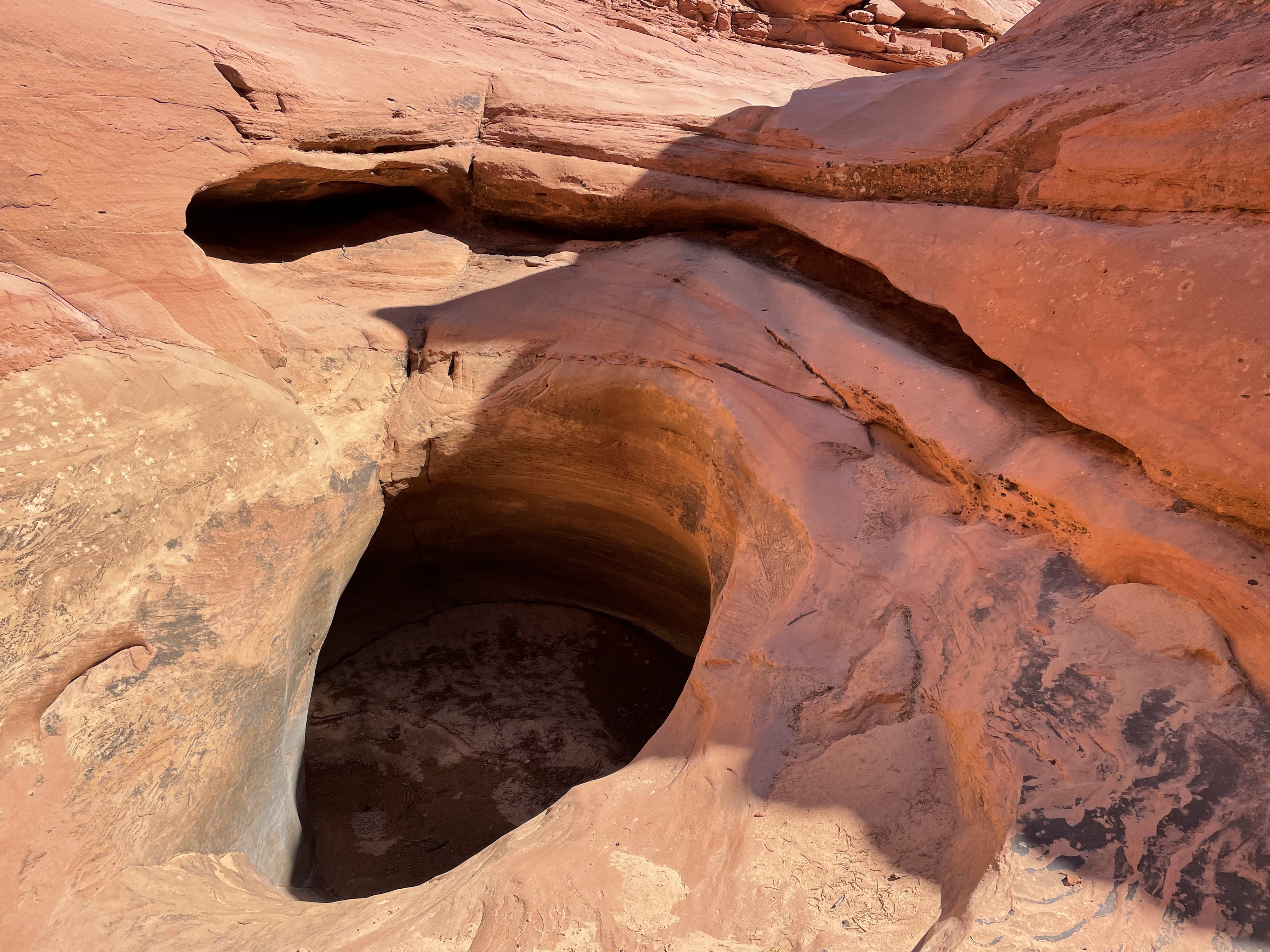
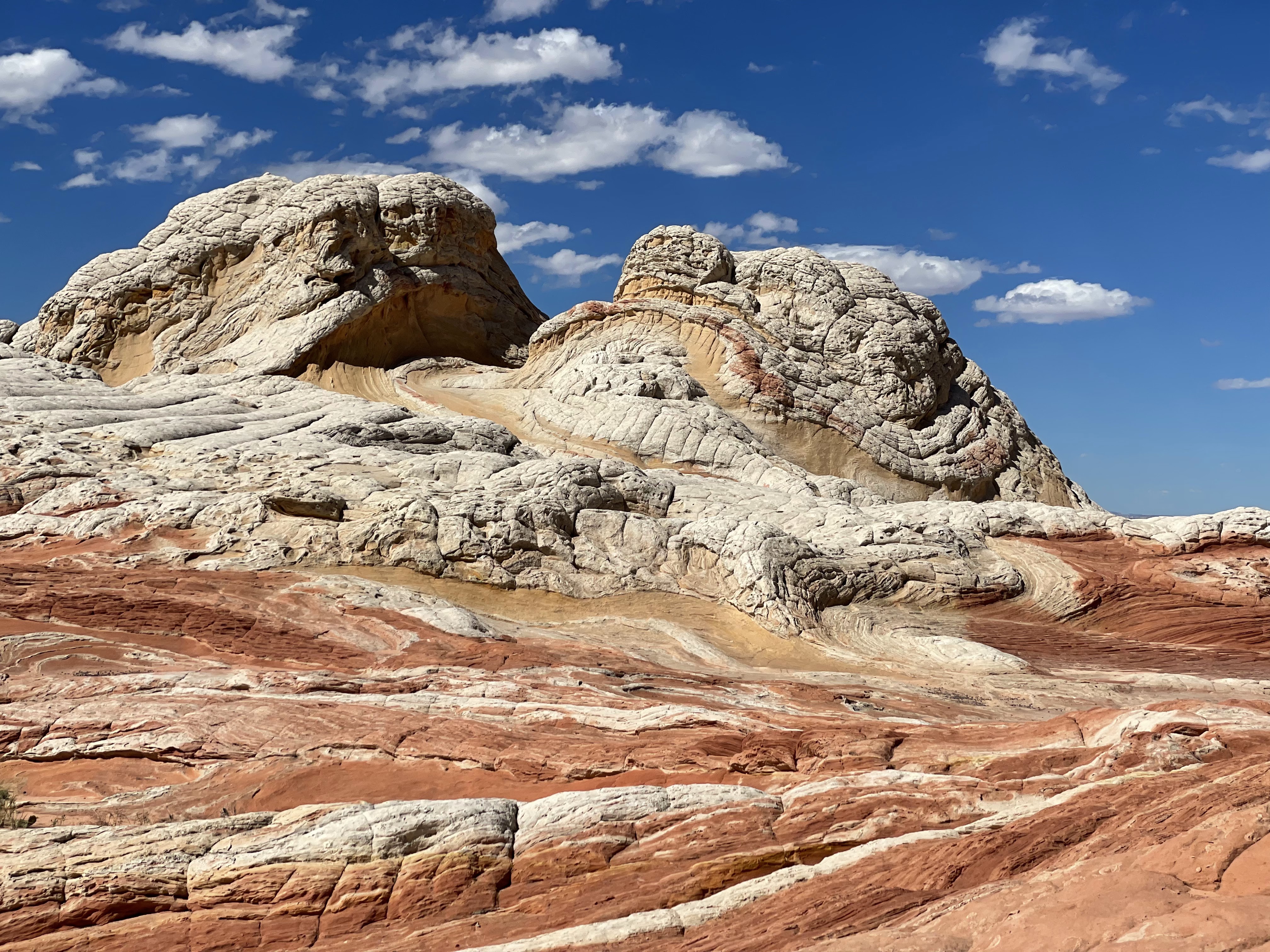
Before my recent completion of the Hayduke route I spent some time in the Kanab area for some day hikes and shorter backpacking trips. One such trip led me to the Paria plateau, specifically the so-called White Pocket. Pockets is the term for slickrock surfaces that are used to collect water for watering cattle. Some of the pockets on the Paria plateau are still used for this purpose, White Pocket fortunately not among them. It is fenced off, an area of about 200 x 500 yds, and thus you only have to contend with other visitors and not with bovines. Over the course of about 2 hrs in the late afternoon I saw maybe 10-12 people in different groups.
I hiked to White Pocket from Lone Tree TH located along House Rock Valley Rd (BLM 1065) that connects Hwy 89 and Hwy 89A. Based on my experience I suggest to drive in from Hwy 89A along BLM 1065 rather than from the Kanab side. This portion of the road is much less rough than that coming from Hwy 89.
The hike from the trail head is along BLM roads which are deeply sandy. BLM warns potential visitors to not drive these roads unless they have a 4WD vehicle and high clearance and know what they are doing. Having walked these roads, these warnings seem appropriate to me and should not be interpreted as scare tactics. There is another approach via BLM roads 1017/1087/1086, starting further West along BLM 1065. I have not used these roads myself and can’t comment on how much better they are in comparison to the ones I walked on. They are supposed to be not as bad as the ones I walked, but 4 WD and high clearance is still required. Maybe one can get away with a little less skill.
The roads I walked pass by the Southern border of Coyote Butte South. To enter the Buttes, you need a permit but you can walk past them without one. There is no water source along these roads, so proper preparation is key. Owing to rains the week before there was water in potholes at White Pocket itself, but you should not rely on this being the case. A ranger at White House ranger station suggested hiking to just Poverty Flat so that you can avoid lugging water all the way and back. That’s a consideration, but it would be difficult to get to White Pocket at first light from there (see below). However, you might consider caching water at Poverty Flat for the return hike.
Sculptured sandstone just outside Coyote Buttes South
I camped at the trailhead and started my walk in the early morning. The approximately 10 mile hike took me six hours, a reflection of the sandy nature of the road and the heat. On the way back, on an overcast day, I walked for 4.5 hrs back to my car. My plan had been to use the late afternoon light at sunset to get some pictures, to then camp nearby and maybe get some additional pictures at sunrise. The way White Pocket is oriented you don’t get much out of the late afternoon light. The crazy sandstone structures are mostly in the shade and therefore the alpenglow does not work with the color of the rock. By contrast, the sunrise light gives you what you want. It was just so cool! Alas I had maybe a minute of this fabulous light since the morning was overcast as mentioned earlier. So keep this in mind when you plan your visit. I camped in the bushes nearby, I think not entirely legally, but there are lots of trees to hide behind and if you want to take pictures early, you need to get up early before a backcountry ranger is likely to show up.


While Pocket in the afternoon
and at sunrise
Yellow Mountain
Yellow Mountain is located along Cottonwood Canyon off Hwy 89, West of the White House TH. Previous attempts to hike it had been unsuccessful since I was not able to find the entry. Since I am nothing if not persistent, this time I figured it out. So here’s the deal: as you drive along Cottonwood Rd from highway 89 eventually you pass the TH for the Paria Box canyon on your left, continue on until you reach a road (Brigham Plains Rd, BLM 430) coming in from the right, about half a mile before you reach the Hackberry Canyon TH. Park at either the latter or off the road that comes in from the right. Make your way down into the Cottonwood Creek drainage, pretty much at right angle to the road. There is no trail, just take the path of least resistance. It can be muddy if there have been recent rains and you have to find your way through tamarisk and Russian olive. It’s about a quarter mile, so the “suffering” is finite. Eventually you reach the creek and its sandy bed, cross it and continue towards the rock face. Turn downstream for a few hundred yards and the first opening on your right is where you want to go.

As you walk in the sandy drainage look to your right, you should be seeing a relatively faint, steep use trail on your right. This trail climbs the slope in switchbacks, becoming rocky as you approach a false ridge near the top. Continue climbing in the same direction after getting over the false ridge until you reach a true ridge (you can look down the other side). You should be seeing some cairns leading you in the direction of Yellow Mountain, now clearly visible to the West. There is a little bit of climbing to do along a cairned use trail before you descend into a hollow made up partly of slick rock and partly of sand. At the bottom you can step onto the slick rock that is Yellow Mountain and can make your way towards the top of the mountain. The colors and the fine structure of the rock are simply amazing!


When I was there it was an unusually clear and crisp day, no trace of haze as far as the eye could see. From the top I saw several areas I will be exploring the next time I am in the neighborhood.
Capitol Reef to Stevens Canyon
This trek is probably the most popular Hayduke alternative to get from Capitol Reef, after coming from Swap Canyon, to Hurricane Wash for all those for whom 14 miles of bushwhacking down the Escalante is not the idea of a good time. I had attempted this twice before but had always had to turn back because the water info I had was inaccurate. This time I was successful! The fly in the ointment this time was different in that it was extremely hot with a heat dome sitting on top of the Southwest for days on end. This forced me to do something I have never had to do before: a long siesta between about noon and 3-4 PM. Obviously this slowed me down considerably, but I don’t think I would have made it any other way.
I parked at Upper Muley Twist TH, walked down to the Lower Muley Twist TH and went down Lower Muley Twist canyon. This was the second time I have hiked it. It is long, about eight miles as the crow walks, and you have to watch your feet most of the time. But the scenery is worth it for sure!
I camped near Muley Tanks, which were not nearly as full as I had expected based on the severity of the summer monsoons in ’22. This reminded me that these monsoon downpours are often rather patchy. The fact that Round Valley Draw got a once-in-hundred-years flood does not mean that Capitol Reef some 20 miles to the East would be getting the same! I made my way down Grand Gulch and picked up some water South of the Southern end of the Hall’s Creek Narrows, which I did not visit this time. After camping under some giant cottonwood trees, next day I continued to the Southern border of Capitol Reef along use trails on the right bank of Hall’s Creek. The transition from Capitol Reef NP to Glen Canyon National Recreation Area is not marked at all and the use trail continues. Something I had not expected.


I had my siesta at the confluence of Halls Creek and Millers Creek, the latter providing good water. I continued further South to the fifth drainage coming in from the right past Millers Creek. There I got good water as I crossed a brushy drainage. I did not have to find the spring shown on the USGS map, the water runs towards Hall’s Creek in a deep, overgrown trench. Careful here, that trench is deep and you do not want to step into it accidentally. You may be wondering about my water consumption. It was in the high 90's in the PM, so I was pushing it back as if it was water.
Continuing on the use trail I was pushed in the direction of Hall’s Creek as I approached the deeply entrenched creek coming from the cliffs to my right. Eventually I latched onto a use trail that led me through the reeds and tamarisk to the bank of Hall’s Creek. I crossed it and camped on a sandy bench under giant cottonwood trees. I had intended to get water from the creek coming out of the drainage South of the 4008 USGS marker, but while I could hear the water gurgling as it entered Hall’s Creek, I could not get physically near the water. The vegetation is just so thick.
Hall's Creek and the green wall on its West Bank
Instead I purified some water from Hall’s Creek and then wandered downstream in search of a spot where I could get onto and through the thicket on the right bank. And there was an opening, either from trail work done a long time ago or a game trail, high up on the bank. I pity the longitudinally challenged! I bent down some Russian olive shoots and pulled myself up. After bushwhacking through reeds, tamarisks and Russian olive for about 50 yards I stepped on a wide open dirt bench with the slick rock face of the Circle Cliffs before me. I followed a cow or use trail West and entered a brushy area, made my way through it in a generally Southerly direction and ended up right up at the foot of a slick rock face that I could climb.
I had marked the Baker route on my map based on Jamal’s data, but somehow all day I climbed and never made my path align with the route. I saw some massive cairns that were nowhere near the Baker route on my map, which just goes to show that cairns really do not tell you a hell of a lot. Anyone can make one for their own reasons and, since they do not leave a note behind stating their reasons, you have no idea what if anything it means.
Look back to the Henrys and ranges further South
Look back across the Lake Powell High Water Plain
Approximately two thirds up the slick rock I encountered some pools that I foolishly walked past thinking that there would be more higher up. And maybe there are, but there certainly were none where I was walking! I ended up too far North and too high up, the latter being a consequence of the former. I just could not see a way through the steep cliffs (next time, if there is a next time, I will try to link up with Jamal's route/original Baker route in order to avoid the complication up top). After I had reached the top I had to descend while walking South near the broad crest. The terrain up there is complex with lots of fine structure that does not show up on the map with 40 ft contours. If you look at the map you’d think that peak 5658 should be standing out. It does not!
As the afternoon light started to fade finding water became job #1 and after a concentrated search I found a very generous pothole in a slick rock drainage. I camped nearby and next morning left the site with four liters.
Just in the nick of time I found this pothole
I found my way around the Eastern end of the major drainage up there, passed behind a major slick rock dome where I found some cairns and made my way into the drainage that would lead me West. I think this is all more complicated than it needs to be. On the North side of the slickrock dome is a dryfall that one can climb and there is a way into the drainage coming from East of the dryfall. There is about a mile that one could save oneself, but that’s hindsight and not readily apparent in this convoluted terrain.
Major slickrock dome, looking upcanyon from where the standard route enters the wash
Dryfall North of slickrock dome
The drainage West is reasonably easy to walk and at what one point a use trail takes off to the right that one might believe is just there to cut off a loop in the drainage. It is not! It is the beginning of the traverse to “Exit” canyon.
The domes above the East end of Exit canyon
Traverse to Exit canyon
Traverse to Exit canyon
"Exit" canyon near its Eastern end
You walk around the East end of Exit canyon and then head West again. There are some sparse small cairns until you see a major cairn made out of red rock. This is your sign to approach the abyss to your left and once at the rim, you see cairns below that get you two levels down. I then headed East again to enter a slickrock drainage at its top, walked around two dryfalls/potholes and came to another dryfall that I could bypass on its right (LDC).
Potholes in Exit canyon
On the ledge in exit canyon
Junction of Exit canyon and Stevens Canyon
After that it was just an easy walk in the drainage. There were potholes with water and shade and then you step onto the ledge on the left side (LDC) and walk that until you come upon the junction with Stevens Canyon.
Continue on the ledge until you reach the point where you can descend to the Stevens drainage. At this location a down-sloping ridge is pointing West. It has some fine structure like three fingers, say index, middle and ring finger with drainages between the fingers. If you walk the ridge of the rightmost finger you have an easy slickrock walk down to a dryfall. You can easily step through it onto a tilted slickrock plate which you descend to another small dryfall. That you can step through easily as well and you are down in Stevens canyon! The rest of the way down Stevens I have described in one of the earlier Grand Staircase Escalante Sundry II entries.
What a hike!


 and at sunrise